MAPPING DESTITUTION ONTO THE GEO-BODY OF TIBET
Blog two of four on POVERTY, IMMISERISATION and DESTITUTION in TIBET
China’s official designation of the whole of the Tibetan Plateau as inevitably and incurably poor is grounded in a line across the map of China drawn by a geographer in 1935, still hailed today as a breakthrough.
The 1935 line creates a neat division of China into two contrasting zones, bisected by a satisfyingly straight line drawn from the southwest at the bottom of the map, up to the northeast at the top. Its’ inventor, geographer Hu Huanyong, pointed out this neat division of China into a densely populated east and south, and the sparsely populated rangelands of the west and far north.[1] It makes for a dramatic contrast, readily lending itself to the formulation of a Marxist “contradiction”.
The southeast half region only accounted for 36% of the land but housed 96% of the population while the northwest half accounted for 64% of the land area but only 4% of the population. This had to be problematic.
In reality it was simply China discovering that, largely through conquest, it had acquired a vast hinterland that does not conform to the Han norm of what is normal, of densely settled, intensively farmed peasant holdings. China did not know what to do with lands not classifiable as arable, not suitable for intensive cropping, and has been struggling with this ever since.
With Hu Huanyong’s 1935 dissection as the starting point, it is then easy to attribute the allegedly abnormal low population density of the rangelands to ecological factors, including mountainous terrain, limited rainfall, cold climate and high altitude. Tibet has all these attributes. Given the inherent assumptions inbuilt to the Hu-line, it is but a short, derogatory and stigmatising step to label the west a “contiguous destitute area”, a fact of nature.
 The reification of this bluntly insulting concept of “contiguous destitution” is strengthened by turning to several new sciences to provide seemingly objective definitions proving ecological determinism. A 2016 report, Coupling between ecological vulnerability and economic poverty in contiguous destitute areas, China: Empirical analysis of 714 poverty-stricken counties, was authored by scientists from institutes of geomatics, resources, environment, tourism, 3D Information Acquisition and urban planning. [2]
A penniless pauper has more thoughts to think
A cloudless sky has more expanse to show
Now all of Tibet is contiguously destitute. The circle of circular logic is complete. Starting with drawing on the map a dividing line between upland, western, cold, subsistence economies and lowland, eastern, farming and urban wealth accumulating economies, it is now self-evident that the contiguous destitution of Tibet, and the rest of the west, is ecologically determined. This is reinforced by scientific languages, “so as to build the model to reveal the coupling between ecological vulnerability and economic poverty. The results show that Hu-Line could act as a feasible partition label to depict the spatial distribution patterns of ecological vulnerability, economic poverty, as well as their coupling degree in contiguous destitute areas.”[3]
This derogatory attitude is not new. Marxist determinism declared Tibet backward, primitive, “green-brained” and in need of a cultural revolution that smashed everything old. Now Marxist determinism has taken on a new dimension, adding natural categories such as altitude, slope, depth of river valleys, cold and thinness of the air, to make an even stronger argument for seeing Tibet only negatively, defined by what it lacks.
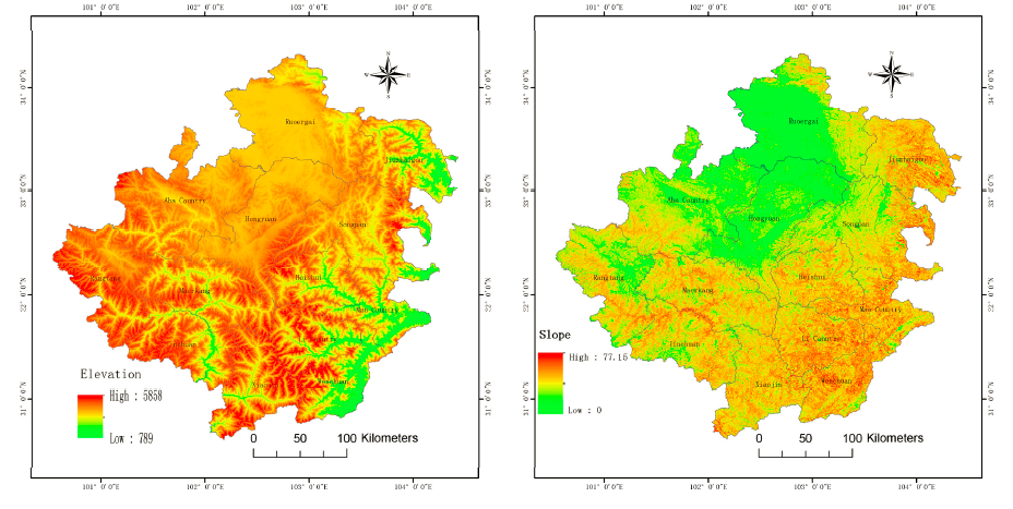
 Amdo Ngawa: remote sensing satellite-generated maps of altitude and slope: proof of inevitable poverty
From this circular logic, it is only a short step to declare that since the drylands/uplands west of the Hu-line are “ecologically vulnerable”, the essential first step in alleviating poverty is to protect ecologically vulnerable areas, including the whole of the Tibetan Plateau, even if protection in practice means depopulating it. The same team just cited goes on to assert: “In addition, there existed a symbiotic positive correlation between ecological vulnerability and economic poverty, therefore, the strategic significance of ecological and environment protection in poverty stricken areas should be specifically emphasized to reduce economic poverty by synchronously protecting the ecological environment.”
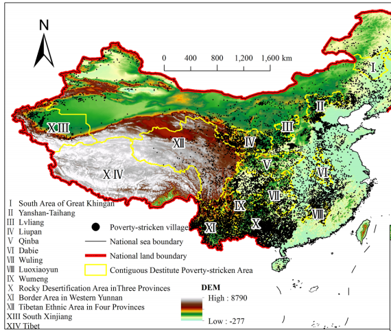
This map, published in 2017, shows the dramatic expansion of the yellow-lined idea of “contiguous destitute areas” to include the whole of the Tibetan Plateau, designated as Zones XII and XIV. This inflation of the “contiguous destitute areas” concept makes it no longer possible to intervene skilfully with targeted poverty alleviation projects designed to raise local incomes by building on comparative advantage, traditional specialties and local strengths. By adding the whole Tibetan Plateau –one quarter of the entire land area of China- the only possible solution to contiguity stretching for thousands of kilometres is removal of the population.
Yet this map also shows poverty as having precise locations –the little black dots. On this map poverty is both more precise and more generalised, across lowland China (dots) and the Tibetan Plateau, defined not by dot locations but by political provincial boundaries.
This is the current map of the poverty planners, replacing the clustered county-level map previously used to define poverty, especially contiguous poverty.
The map (and article in English) is in the journal Social Indicators Research, 2017. [4] The colours of the map signify demographic density.
When opulence sits astride a horse
The heart of poverty freezes
PRECISION OR PREJUDICE?
As big data accumulates, China announced, in the early years of Xi Jinping’s rule, that it was moving away from defining and targeting poverty at county level, and was now able to be more precise, targeting poor villages and poor households. The era of precision poverty alleviation was heralded as yet another Chinese advance, to pinpoint and thus effectively eliminate poverty, as and where it occurs. The new precision was based on ground-level household surveys, an exhaustive accumulation of data generated by aggregating all the village level surveys, and households registering themselves as poor.
Designating an area the size of all Western Europe –the Tibetan Plateau- as a “contiguous destitute area” is the opposite of precision. Instead of identifying specific pastures that are less productive, specific villages that are off-road and off-grid and unable to access markets, specific farming districts in need of investment in new seed varieties, specific towns in need of stockyards to keep livestock in good condition during the sales process, there is now a sweeping lack of specificity. Despite China’s keenness for territorially defined precision, Tibet is generalised, swept in its entirety into a category of irredeemable destitution.
By making the entire 2.5 million sq kms of the Tibetan Plateau “contiguous destitute area”, the very idea of contiguity has been nullified. The point of the concept of contiguity was to pinpoint those local factors that cause or perpetuate poverty. Local factors, including local community skills and aspirations that, with investment, can provide local solutions to local problems.
But when the entire plateau is classified as “contiguous destitute area”, there is nowhere to turn, nowhere to go, no local solutions to be found. It is no longer possible to encourage poor villagers to move elsewhere nearby, in their familiar home on the rangeland, where opportunities may be better. It is no longer possible to train local communities in skills they can acquire, enabling them to develop new livelihoods, in their home districts.
Once the whole Tibetan Plateau is negatively classified as “contiguous destitute area”, there is only one possible solution to poverty, which is to depopulate the entire plateau, and move the whole population from their lands, initially to urban fringe camps, nodes of global modernity in Tibet, then to cities beyond Tibet, on the grounds that labour mobility is a necessity since capital investment has never come to rural Tibet, and never will.
A GREAT LEAP IN CONTIGUITY
The original 11 “contiguous destitute areas” were a concerted effort to identify, reach and engage the poor where they live, covering a total of 505 counties in 19 provinces and cities, almost 15 per cent of China’s total area. The three new “contiguous destitute areas” added in 2011 encompass a further 25 per cent or more of China’s territory, so a total of at least 40 per cent of China by area is now officially destitute, even though the number of poor people is so few. The whole concept of “contiguous destitute areas” has been muddied by these two incompatible concepts now sitting, literally, alongside each other.
On poverty maps of today’s China, there are the little black dots signifying poor villages, many of them sufficiently scattered to not swarm in clusters, thus not qualifying as contiguous. Then there are the thicker clusters of villages sufficiently close to each other to be lumped together as “contiguous destitute areas”, a category that crosses provincial boundaries, wherever the data leads. Both the dots and the clusters arise from laborious, grounded, village by village, household by household poverty mapping. This is the basis of the 11 “contiguous destitute areas”, the focus of intensive poverty alleviation project work, until China’s new era.
Then came the 2011 expansion, at the time of Xi Jinping’s rise. There are now three more “contiguous destitute areas.” Two of the three are the entirety of Tibet Autonomous Region, including the vast northern empty plain of the Chang tang where there are almost no villages at all; and the “Tibetan ethnic areas of four provinces”, China’s clumsy circumlocution for the other half of the Tibetan Plateau, including all 75 counties in Yunnan, Sichuan, Gansu and Qinghai provinces designated officially as Tibetan Autonomous Counties. Making up the 14th “contiguous destitute areas” is the new addition of southern Xinjiang.
These new areas have been mapped and defined, not by village surveys and gradually accumulating ground data, but on the basis of completely different criteria, which are wholly political. The boundaries of the three new “contiguous destitute areas” are provincial and prefectural, not based on actual locations of villages. There is nothing contiguous, or ecologically predetermined, about them. They are political artefacts, no longer moored in survey data. They are declarations, at the highest level of a centralised, authoritarian party-state, that Tibet, in its entirety, and the most Uighur of Xinjiang’s prefectures, are intractably, irredeemably, incurably destitute, beyond redemption and in no way suited to targeted poverty alleviation projects.
China used to blame the backwardness of Tibet on Tibetan culture. Now the seemingly scientific concept of “contiguous destitute areas” shifts the blame onto neatly mappable data on terrain and climate. Yet the social determinants of backwardness and destitution persist, in what China counts as constituting contiguous destitution. It’s a package of loss, absence and lack, all of which define Tibet and the Tibetans, who have low human capital and high altitude, high mountains and a low “social capital index.” Everything measurable, natural and human, is all a form of capital, and Tibet scores low on all forms. All of these are rolled into the ecological determinism that makes destitution inevitable.
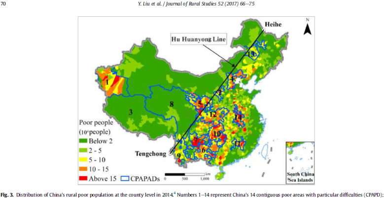
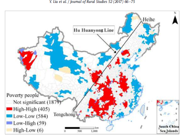
By now, this has been repeated so often, it has been naturalised, as a self-evident truth: “The CAPADs[contiguous poor areas with particular difficulties] tend to the ecologically vulnerable zones where there are poor living conditions, frequent natural disasters, weak economic foundations, poor infrastructure and lagging public service, and special social fabrics. They also feature large land acreage and great difficulties for poverty reduction and thus are categorized as the least-developed regions in China. Covering most state-designated poverty counties and key relief recipients, these areas are home to the largest number of rural poor with the highest poverty incidence rate. The distribution of the Chinese rural poor exhibits a distinct spatial agglomeration feature. Poverty is mainly concentrated in the remote deep rocky mountainous areas, border areas and minority areas of central and western China. The lack of natural endowments, poor geographic conditions and fragile ecological environment are the main driving forces behind persistent poverty. Complex geographical environments, frequent natural disasters, poor infrastructure and minority population agglomeration may be the main reasons behind the regional disparity of poverty. Most of the key impoverished counties suffering from frequent disasters are located in China’s western regions where there is a fragile ecological environment and an agglomeration of ethnic minorities.Furthermore, a high degree of overlap exists between the national key ecological function areas and the contiguous poverty-stricken areas with special difficulties in China. Poverty-stricken families usually live in remote areas in a harsh environment under poor living conditions and suffer from a high re-poverty-stricken rate.”[5]
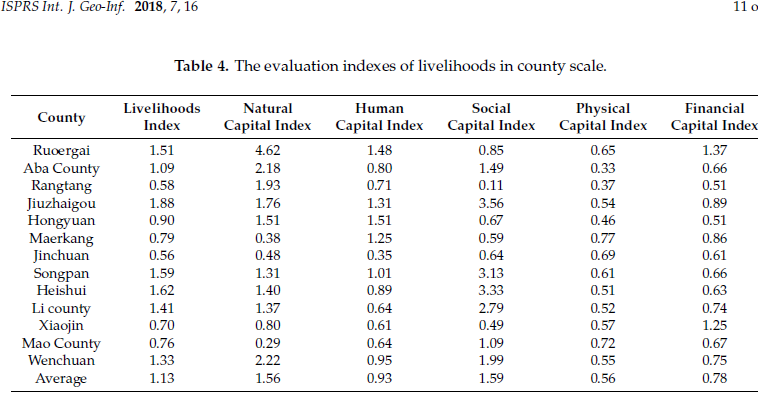
When looked at more closely, China not only argues that altitude and climate determine Tibetan destitution, but that “contiguous destitution” is the result of ethnic contiguity, a racist assertion reminiscent of the Cultural Revolution. A 2018 article in an open-source journal is headed: Assessment of Sustainable Livelihood and Geographic Detection of Settlement Sites in Ethnically Contiguous Poverty-Stricken Areas in the Aba Prefecture, China. [6] Is it the contiguity of the Tibetan ethnos that causes the poverty, or the lack of factor endowments that causes poverty? Or are they the same thing? In short, is lowland China making the ridiculous assumption that no human would choose to live in Tibet, if they had a choice?
What used to be 505 counties has suddenly become 1311 counties: “To be specific, there are 53,758 villages involved, covering 13 contiguous destitute areas, 27 provinces, 1311 counties. Overall, they are mainly distributed in Central and Western China. According to the county-scale poverty level, the counties involved here constitute 527 national poor counties, 439 provincial ones and 345 non- poverty ones; from the view of geographical division, they can be classified into 94 eastern counties, 442 central ones, and 775 western ones; In terms of the primary industry classification, they contain 83 pastoral counties, 117 agricultural-pastoral ones,and 502 agricultural ones; According to the terrain classification, there exist 598 mountainous counties, 303 hill ones, 264 plain ones.”[7] Yet Tibet Autonomous Region (TAR) remains a blank on the mapping of actual poverty, contiguous or otherwise: “Tibet Area is also excluded from the study due to regional data privacy,” a polite reference to poverty data on Tibet being a state secret. TAR is routinely omitted from many reports, because its situation so embarrassingly contradicts the official narrative of new era great rejuvenation fulfilling the China Dream.

DOES CHINA STILL DO GRASSROOTS POVERTY ALLEVIATION?
Beyond Tibet, some of the mapped black dots signifying poor villages are in areas to which the fleeing People’s Liberation Army retreated in the 1930s. These “old revolutionary areas”, though still poor, inspire a special place in CCP history, and Xi Jinping has visited many of them (none in Tibet) to express his care and concern. On one such visit, he focussed on what the local economy is good at, emphasizing his pledge to help them build on their local strengths: “Yanchuan County Party Committee Secretary Liu Jingtang focused on the practice of realizing the rapid growth of farmers’ income through the development of specialty products such as red dates and apples. The general secretary Xi Jinping asked, how are the red dates selling now? What do people eat when they buy it? Liu Jingtang made an answer. The general secretary must strengthen market research and master market conditions. Zhitan County Party Secretary Yang Dongping also talked about the use of local resources to develop agricultural and sideline products. The general secretary knows in detail the situation of their production of wolfberry wine and asks whether the production and sales are in the right direction. They must pay attention to opening the market.” 
China still talks of local solutions to local problems, as does the World Bank, in its poverty alleviation work in China (but not Tibet). In reality, now that poverty alleviation has become a “critical battle” of national and international importance, China is in a hurry, and in no mood for the slow and patient work of engaging and encouraging local communities to organise themselves into water user groups, farmer groups, marketing co-operatives and gradually evolve local solutions.
In 2018 Xi Jinping addressed senior poverty work officials from Sichuan, Yunnan, Guangxi and Guizhou provinces (but not Tibet), reminding them to: “effectively strengthen grassroots organizations. To do a good job in poverty alleviation and development, the grassroots level is the foundation. We must organically combine poverty alleviation and grass-roots organization construction, do a good job of building village-level organizations with village party organizations at the core, and encourage and select outstanding young cadres and veterans who have good ideas, good work style, and strong abilities to serve the people. Every poverty-stricken village must have a village work team, and each poverty-stricken household has its own help. The task forces and cadres in villages must concentrate on poverty alleviation and development and play an effective role.”
Yet Tibet remains the exception, with almost no grassroots village organisations designing their own poverty alleviation, with help from central leaders. A decade ago, and two decades ago, there were many NGOs, from China and the world, working in Tibet, building and staffing schools, health clinics, improving farming, alleviating poverty. Now nearly all have been pushed out, excluded by a state that wants to be the sole author of all interventions in Tibet.

Xi Jinping is a politician, indeed, as many argue, the only politician in a dictatorship where all other voices are silenced. Like any politician, he says many things, addresses many audiences, tries to be all things to all people. He talks at length about local solutions to local problems: “Severely impoverished areas should improve their growth models and give priority to the development of business activities that benefit the impoverished, such as agriculture based on local features, labour-intensive processing industries, and the service industry.”[8] This is exactly what Tibet needs, and has needed for the past 60 years, without success. Xi Jinping, in the same speech, says: “We should relocate more impoverished people living under adverse natural conditions.”
These are two mutually incompatible models of what is meant by poverty alleviation, so which strategy is scheduled for implementation in Tibet? Everything points to the six decades of failure to invest in rural production, value adding and marketing persisting. It all points to further displacement of Tibetans from their land, now not only in the name of water provision and wildlife protection, but also poverty alleviation.
How common is poverty in Tibet? Has grassroots bottom-up poverty alleviation been tried in Tibet? That’s in the next in this blog series on POVERTY, IMMISERISATION and DESTITUTION in TIBET

[1] QI Wei et al, China’s different spatial patterns of population growth based on the “Hu Line”, J. Geogaphical Science, 2016, 26(11): 1611-1625
[2] Coupling between ecological vulnerability and economic poverty in contiguous destitute areas, China: Empirical analysis of 714 poverty-stricken counties, 中国贫困地区生态环境脆弱性与经济贫困的耦合关系——基于连片特困区714个贫困县的实证分析, Chinese Journal of Applied Ecology, 应用生态学报, Aug. 2016, 27(8): 2614-2622
[3] China’s different spatial patterns
[4] Yanhui Wang and Yefeng Chen, Using VPI to Measure Poverty-Stricken Villages in China, Social Indicators Research, 133, 2017, 833–857
[5] Yansui Liu, Jilai Liu, Yang Zhou, Spatio-temporal patterns of rural poverty in China and targeted poverty alleviation strategies, Journal of Rural Studies 52 (2017) 66-75
[6] Yanguo Liu, Chengmin Huang et al, Assessment of Sustainable Livelihood and Geographic Detection of Settlement Sites in Ethnically Contiguous Poverty-Stricken Areas in the Aba Prefecture, China; ISPRS International J. Geo-Information, 2018, 7, 16, free download: http://www.mdpi.com/2220-9964/7/1/16
[7] Using VPI to Measure Poverty-Stricken Villages in China, 2017
[8] Xi Jinping, Governance of China, vol 2, Foreign Languages Press, 2017, 94