DIVERTING TIBETAN WATERS INTO THE CANAL TO THE DEEP NORTH
#1 in a series of 8 blog posts on Tibetan rivers
China can and does import every natural resource it needs, with one exception. China can afford to source its raw materials globally because it then exports the products manufactured from them. China now so dominates global commodity markets that a surge of Chinese speculators chased out of the stock exchanges and into commodity futures price gambling can, as at the moment, send iron ore prices soaring for reasons no-one else can understand.
Only one natural resource, or raw material, or commodity stands out: water. It is not as though China, especially urban, industrial China has enough water; on the contrary there is such an acute water shortage in lowland north China that some even call it a threat to regime survival.
Even though all industrial and agricultural production uses water lavishly, resulting in the current shortage, water cannot be imported. Not only is it too heavy to keep ships afloat in the oceans of salt water, China simply needs far too much of it for shipping it in to work. The quantities are unimaginable: tens of billions of cubic metres of pure water urgently needed to keep northern China in the industries to which it is accustomed.
The one source of water that is available to China is Tibet. Cadres in charge of Qinghai province (Amdo in Tibetan) decades ago coined the slogan: Qinghai is China’s Number One Water Tower, and this is now the catchy slogan in command in Beijing too, usually inflated to: Tibet is China’s (or Asia’s) Number One Water Tower.
Everyone now knows that Tibet is full of water, and what’s better, it is upriver, waiting to slide down to the wheat fields of northern China, ready to grow more dumplings.
Much water does come from Tibet, flowing west, south, east and southeast, watering most of Asia. Tibet’s flowing waters incise into the Tibetan Plateau, eroding the rising plateau. That is why the Yellow River is yellow, why China’s loess plateau is hundreds of metres deeply filled with silt, and why yellow is the colour special to the emperor, starting thousands of years ago with the mythical Yellow Emperor. The iconic colour China takes as definitive, is Tibetan.
Yet in reality, on any precipitation map of China, the Tibetan Plateau is one of the more arid regions, receiving only the tail end of the monsoon rains the Plateau generates. It is lowland China, especially in the south, that receives far more of the monsoon bounty of plum rains.
But eastern Tibet, both in Kham and much of Amdo, does receive good rain, and the high peaks capture every drop of passing moisture, holding it in glaciers which release steadily year-round. So the official water tower slogan, both boon and bane for the future of Tibet, has a basis.
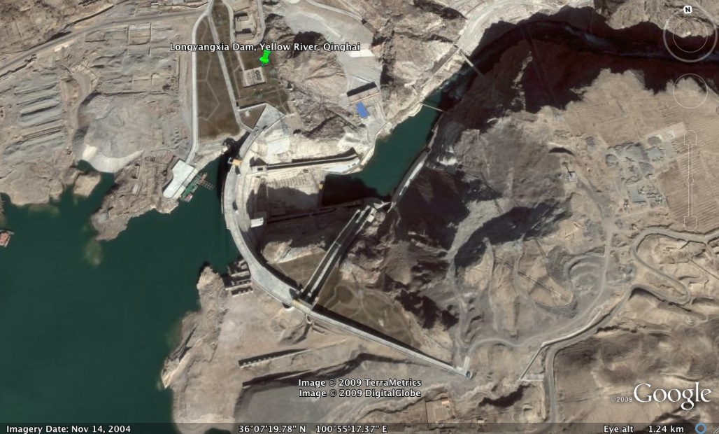
For sixty years China’s leaders, scientists and hydraulic engineers have looked for ways of getting more water to northern China, by draining water from the mighty upper Yangtze (Chang Jiang in Chinese, Dri Chu in Tibetan) and sending it north to the Yellow River (Huang He in Chinese, Ma Chu in Tibetan) or direct to thirsty cities of the north, including Beijing. Many maps have been issued, over many years.[1]
The solution so far has been canals, dug at great expense, and at great human cost to the many displaced by them. This is part of a long tradition of imperial hydraulic engineering, that has long legitimated the rule of emperors who succeeded in controlling the rivers; and upending their rule when they failed. The two huge canals that began operation recently do much to alleviate the shortages in the north, but not enough.
Officially these two canals were the first two of a three-stage grand scheme announced at the start of this century, the third being a canal across eastern Tibet to take water from tributaries of the upper Yangtze and send it to the upper Yellow River, all within the Tibetan Plateau. The package of three canals were collectively called the South-to-North Water Diversion project, abbreviated here to S2N. The three canals were the Eastern Route, the Central Route and the Western Route. All along, the plan was that first the eastern and central canals would be built; then the team of engineers would start on the western route, through Kandze and Ngawa Tibetan Autonomous Prefectures, in Sichuan. The two lowland canals were completed by the time the 12th Five-Year Plan ended in 2015, a triumph of supply-side solutions to problems of unchecked demand.
CHINA’S LATEST FIVE-YEAR PLAN TO CAPTURE THE WATERS OF TIBET
Would the 13th Five-Year Plan announce the start of the S2N western route through Tibet? That is a question this blog has focussed on before, and the answer is now clear. In March 2016 came the official announcement of “Big reservoirs in Tibet and other areas” on a long list of “Major Projects to be Implemented in coming five years.”[2]
This is new, the first time reservoirs and Tibet have been put into a single policy sentence. There are plenty of dams in Tibet, and plenty more planned, but almost none are reservoirs. These dams are officially “run-of-the-river” dams, designed to impound only as much water as required to build up pressure for its release back to the river via hydropower electricity generating turbines. Although many in downstream India are worried these dams on transboundary rivers will impact on water flow downriver, China is adamant that until now the sole purpose of all dams built in Tibet is to make electricity.[3]
Reservoirs are a quite different category, deliberately designed from the ground up to hold as much water as possible. This can be for two primary purposes. Both require holding water for many months, until it is most needed. Both thus impose a heavy load on the surrounding landscape, which, in Tibet, is full of fault lines straining against each other until the suddenly slip, in an earthquake. There is now much evidence that the sheer weight of impounded water in big reservoirs can induce earthquakes, both because of the weight pressing from above, and because water seeping through cracks directly lubricates the fault line.
One major purpose for building big reservoirs is to divert water away from the river, to some distant destination, by canal and/or tunnel. The other major purpose, in Tibet, is to store water in the rainy summer months until it is needed in the drier winter further downstream, to reliably turn hydropower turbines and reliably generate electricity.
Both purposes necessitate greatly interfering with the natural environmental flow of rivers, disrupting the life cycles of all animals of the watershed. Both require holding water back in huge volumes until distant users need it. Both exist for exporting a commodity to distant users, whether it is commoditised water sent via other rivers; or the hydropower generated downstream on the same river below the big reservoir, which is ultimately consumed by cities 1000 or even 2000 kms away.
The construction of reservoirs to boost hydropower generation will be considered more closely in a later blog in this series, here we look more closely at reservoirs for water diversion.

WHO BENEFITS?
Will these new reservoirs serve the Tibetan people, providing water for fast growing cities, or for farmers and their crops? Are Tibetans the intended beneficiaries?
Irrigation is an ancient practice in Tibetan cropping villages. Even in far western Tibet, now too dry to support crop growing, archaeologists find ancient stone lined irrigation channels that once kept village fields well-watered.[4]
There is scope today for improving irrigation in the food bowl of central Tibet between Lhasa and Shigatse, and several projects, such as the European Union financed Panam project of the 1990s, have done so.[5] However what is needed is not “big reservoirs”, but many much smaller dams, on tributaries of the big rivers, for local water supply, especially in spring, as plants begin to grow well before the summer monsoon rains arrive. Big reservoirs are not required to improve the productivity of Tibetan farming. Climate change is bringing more rain in spring, but still not early enough, on a high plateau with a very short growing season.
Likewise, the booming cities of Tibet generally have ample water supply from the rivers they are built on, with no requirement for “big reservoirs.”[6] Villages in Tibet often lack access to drinkable water, and benefit greatly from the laying of plastic piping uphill to reliable sources, which may also require construction, in the hills, of a small dam, but not a “big reservoir.”[7]
DEFYING GRAVITY
The new “big reservoirs in Tibet and other areas” (that are not usually considered by China to be Tibet, yet very much on the Tibetan Plateau) are quite different, starting with the actual design of the dams. These are big dams, not only because they must hold much more water than electricity generating dams, but they are much taller, for a very specific reason. One is so high it will be the second tallest dam in the world.
Despite decades of engineering research and planning, one major problem has always gotten in the way of realising the dream of capturing Tibetan waters and diverting them to northern China. The inescapable reality is that, at those points on upper Yangtze tributaries closest to the Yellow River, the Yellow riverbed is at the least 80 metres higher. At other temptingly close distances, it is as much as 450 metres higher.
Water can be pumped up hill, but it takes enormous amounts of energy to do so, a cost both to construct and operate, which greatly alters the economics of the entire project, as the ultimate users of the diverted water will certainly have to pay for it. Unlike the railway from Chengdu to Lhasa, now under construction,[8] which makes no business case, there must be water users downstream with both the capacity and motivation to repay the costs of construction, as water is a saleable commodity once it has been impounded.
WHO WILL BUY TIBETAN WATER?
What has delayed this Tibetan water diversion project for so long, and may yet see it again shelved, is not engineering problems, but cost. Even when upper Yangtze tributaries are separated from the upper Yellow by a mountain range, there is no longer great technical difficulty in boring a tunnel right through the mountains; in fact almost all of the three “canals” of the three Tibetan routes of S2N water diversion will be tunnels. China has shown recently that tunnelling through a Tibetan mountain range, despite the seismic risk, can be done, when it tunnelled the Chokle Namgyal Range (Qilian in Chinese) that separates northern Amdo from Gansu, for the new high speed rail line from Lanzhou via Xining, under the Qilian and into Gansu, then on to Xinjiang. Tunnelling may be costly, but technically China can do it, even, in the 13th Five-Year Plan, proposing a long undersea tunnel to connect China to Taiwan.
The problem is cost, exacerbated by water’s unwillingness to defy gravity, and the impossibility of finding tunnel routes that aren’t uphill. The simplest solution is to build the dam walls so high that gravity can be utilised, and pumping costs minimised, or in at least one of the three routes, no longer needed at all.
The three Tibet water diversion routes can be built as three separate projects, over a long period if need be, but the official website of the project insists they must be done in a certain order. First, and at a high altitude, is the Yalong River Water Diversion Line, requiring a tunnel 131 kms long.
The project promoters state: “Bayankala Mountain lies between Huanghe River and Changjiang River. The elevation of the bed of the Huanghe [Yellow] River is higher than that of the correspondent section of Changjiang [Yangtze] by 80-450 m. It is necessary for the water transfer project that a high dam will be constructed for damming water or some pumping stations be set up for lifting water, and some long tunnels will be driven through Bayankala Mountain. Two methods of water diversion, flowing by gravity and by pumping were considered. But for each of them, a high dam in height of 200 m or so will have to be constructed and some long tunnels over 100 km in length to be driven.”
This remains the primary obstacle, greatly increasing cost. It is the reason China is now emphasizing “big reservoirs.”
Northern China’s chronic water shortage is well known, so one might suppose that diversion upstream of Tibetan headwaters will firstly benefit urban consumers now reliant on ever-deeper wells chasing an ever-sinking water table. However, the flow to be diverted to the yellow River, even if it all works according to plan, is insufficient to reach the long last section of the Yellow River, where the water shortage is most acute.
The diverted water will at best flow to the mid-section of the Yellow River, to provinces such as Gansu, Ningxia, Shanxi, Shaanxi, Inner Mongolia and to industrialised districts of Qinghai. These are provinces with less political weight than the richer downriver provinces where water is most acutely deficient, but they are the source of most of China’s coal, thus supplying most of China’s energy, whether through burning coal for power generation close to the coal deposits, or sending the coal by rail to coastal China for burning there.
[1] Water Resources and Hydropower Development in China, Scientific & Technical Information Institute, Ministry of Water Resources and Electric Power, Beijing, 1986, 36
[2] China’s major projects to be implemented in coming five years, Xinhua’s China Economic Information Service, 7 March 2016
[3] http://www.cprindia.org/articles/india-china-brahmaputra-suggestions-approach http://www.thehindu.com/opinion/columns/downstream-concerns-on-the-brahmaputra/article7834154.ece
[4] Mark Aldenderfer, The Prehistory of the Tibetan Plateau to the Seventh Century A.D.: Perspectives and Research From China and the West Since 1950, Journal of World Prehistory, Vol. 18, No. 1, March 2004
[5] PIRDP – Final Report 2005, EU-China Programme for the Panam Integrated Rural Development Project (PIRDP), April 2006
Water and Primary Health Care for Tibetan Villagers, AusAID, 2002
[6] Basic Data of China’s 288 Cities at and above Prefecture Level in 2011, in The State of China’s Cities 2014/2015, China Science Center of International Eurasian Academy of Sciences, http://unhabitat.org/books/state-of-china-cities/
[7] http://neec.no/tingri-county-wave-reservoir-reinforcement-project/ http://neec.no/qinghai-huang-nangui-germany-county-2016-small-water-conservancy-key-county-project/
[8] http://www.economist.com/news/china/21699167-plans-new-railway-line-tibet-pose-huge-technological-challengeand-political
2 replies on “DROPPING TIBET, FIGHTING GRAVITY”
[…] 2. Dropping Tibet, Fighting Gravity-Diverting Tibetan Waters Into The Canal To The Deep North | Rukor The three Tibet water diversion routes can be built as three separate projects, over a long period if need be, but the official website of the project insists they must be done in a certain order. First, and at a high altitude, is the Yalong River Water Diversion Line, requiring a tunnel 131 kms long. The project promoters state: “Bayankala Mountain lies between Huanghe River and Changjiang River. The elevation of the bed of the Huanghe [Yellow] River is higher than that of the correspondent section of Changjiang [Yangtze] by 80-450 m. It is necessary for the water transfer project that a high dam will be constructed for damming water or some pumping stations be set up for lifting water, and some long tunnels will be driven through Bayankala Mountain. Two methods of water diversion, flowing by gravity and by pumping were considered. But for each of them, a high dam in height of 200 m or so will have to be constructed and some long tunnels over 100 km in length to be driven.” This remains the primary obstacle, greatly increasing cost. It is the reason China is now emphasizing “big reservoirs.” // this is post #1 in a series of 8 blog posts on Tibetan rivers […]
Thanks for letting folks know