British Raj imperial follies of a century ago, justified as empirical science, still haunt the Himalayas and divide Tibetans from each other..
The conceit of Henry McMahon was that he could draw a line right along the Himalayan glacial peaks that would demarcate British India from Tibet, which was further labelled as suzerain to China.

McMahon’s Line is still with us, still defining the tense, highly contested border between India and China, with Tibetan civilisations on both sides, cut off from each other by Sir Henry’s triumph of trigonometry.
The recent sudden catastrophic collapse of a glacier perched high above the deep river valleys of Indian Uttarakhand is also a casualty of McMahon’s logical but absurd peak-to-peak magical line. Initial reporting of the destructive surge of this outbreak flood (as scientists call it) were confused as to what could have caused it, and utterly unaware of recent similar events on the other side of McMahon’s line, thus lacking much basis for comparison.
In the inevitably confusing days after this raging flood smashed through hydro dams and tunnels under construction for river diversion and underground turbine halls, causation was widely attributed to collapse of a glacier, to earthquake, landslide and sudden breaching of a lake, as if these are all discrete phenomena, alternative explanations. A century and more since McMahon and his army of theodolite bearers turned the Himalayas into numbers, we still struggle with proliferating causes and complexity. We still seek, as McMahon did, a single foundational basis, a fundamental truth against which all else can be assessed. We are still startled that, in landscapes as young and growing as the Tibetan Himalayas, the above causes, far from being mutually exclusive, are probably all true, in very short order.
Sir Vincent Arthur Henry McMahon, Companion of the Most Eminent Order of the Indian Empire (CIE), Companion of the Most Exalted Order of the Star of India (CSI), Knight Commander of the Most Eminent Order of the Indian Empire (KCIE), Knight Grand Cross of the Royal Victorian Order (GCVO), was a paragon of Gaelic rectitude, imperial hauteur and Enlightenment rationality. After India he went on the Middle East and was involved in the carve up of the Levant, as the Ottomans crumbled, between Britain and France. The partition of India and Pakistan, two years before his death, was not his work, yet follows a similar familiar logic by deeming two of India’s religious communities as natural categories that are naturally incompatible, the solution being a line on a map.
What the McMahon Line obscures by privileging peak altitudes above all else starts with the glaciers, tens of thousands of them in the Himalayas, some flowing south to north across the McMahon Line, some flowing north to south across the McMahon Line. Who rules?
McMahon’s high Victorian great arc inscribes Enlightenment reductionism onto the most complex, dynamic, constantly growing landscapes on this planet[1]. By joining the peaks in a line, he proclaimed himself a modern Euclid, yet he ignored everything below the peaks, which includes not only the glaciers and the courses of rivers powerful enough to cut right across the line of peaks, but also the lives of the Tibetans on both sides, whose livelihoods relied on being on both sides, not only to trade Tibetan salt to the sweaty Indian lowlands craving salt, but also to tarry with their pack yaks and sheep on the Indian side in the winter trading season, for the animals to find fresh green pick that in Tibetan winter is hibernating underground. Tibetan societies were sealed off from each other by McMahon’s line and, over a century later, still are, to their impoverishment. McMahon’s dissection of the Himalayas dissected the Tibetan world, isolating the Ladakhis, Zanskaris, Mustangpa, Lhopa, Monpa, Bhutanese Druk Yulpa, Demjongpa Sikkimese and Tawangpa, among many others, from their kin in Tibet, and from their customary income earning strategies as traders intermediating between lowlands and highlands. Their poverty and marginality have remained ever since, as they struggle to retain the young who can find no livelihood on the slopes, and everyone struggles to maintain lineages of Buddhist teachers who were usually replenished from the north, in Tibet.
Henry McMahon casts a long shadow. In 1947 the Tibetan government requested newly independent India to return most of these lands to Tibetan control, which Prime Minister indignantly rejected.[2]
McMahon was out to naturalise the geostrategic contest of imperial powers, in this case to demarcate British India from China and also Russia. This is a distinctly European conceit, based subconsciously on European history. John Keay, author of the Great Arc case study of McMahon and his line, published in 2000, reminds us: “mountains, according to Fernand Braudel, are essentially marginal. Over the centuries they act as breakwaters to the great waves of civilization which, while spreading far and wide on the plains, ‘are powerless when faced with an obstacle of a few hundred metres’. Mountains divide and impede; ‘their history’, says Braudel, ‘is to have none’. He was writing in the context of the Mediterranean world. It’s a different story in Inner Asia. There, mountains have rather a lot of history.”[3]
The tumultuous Uttarakhand flood of February 2021 is the latest casualty of this dissection. Had the southern and northern flanks of the Himalayas been understood as contiguous, sharing a deep human history and even deeper orogenic, ongoing uplift history, we might have been better able to reach across that line, to discern very similar events.[1]
- [1] Tina Harris, Trading places: New economic geographies across Himalayan borderlands, Political Geography 35 (2013) 60-68
- Liv Timmermann and Carsten Smith-Hall, Commercial Medicinal Plant Collection Is Transforming High-altitude Livelihoods in the Himalayas, Mountain Research and Development Vol 39 No 3 Aug 2019: R13–R21
- Phurwa D. Gurung, Mountains Are Commons, Grasses Are Divided: Indigenous Environmental Governance Between Conservation And Democracy, dissertation University of Colorado, 2020
- Corinna Wallrapp, Production networks and borderlands: Cross-border yarsagumba trade in the Kailash Landscape, Journal of Rural Studies 66 (2019) 67–76
- Dipesh Pyakurel, Patterns of change: The dynamics of medicinal plant trade in far-western Nepal, Journal of Ethnopharmacology 224 (2018) 323–334
The geologists, hydrologists and glaciologists do try to overcome McMahon’s line, but politics intervenes to this day. Indian scientists are seldom allowed to work in Tibet; Chinese scientists are seldom allowed to work in India. The hydrological data they collect is securitised as state secrets, not to be revealed. The Himalaya is without history, with no human backstory. The Tibetan world, rendered invisible by great power geostrategising, has paid a heavy and ongoing price.
China colludes in erasing the Tibetan histories on all sides of the Himalayas. It suits China well to have a Line of Actual Control that formally disputes McMahon’s Line as an imperial imposition China never signed onto, yet in practice closely follows. It suits China to build “border defence” villages of immaculate modern urban design, further erasing any hint that these waystations or pilgrimage dharamsalas on ancient trading routes ever had a history. It suits China to station missiles, heavy artillery, and armoured vehicles engineered for high altitudes, along this border with no history. China occupies the high ground, metaphorically and literally.
Yet happenstance intervenes. Thanks to the prevalence of drones, in even the remotest and steepest landscapes, the sudden glacial lake outburst flood (GLOF) in Uttarakhand was captured and instantly went global. Who has not seen that dramatic footage of water so wild and violent it smashes bridges as if they were matchbox toys, slamming into hydro dams, drowning river villages and fields in seconds? If there was no drone camera in the air at the right moment on a wintry February morning, at the opposite end of the year to the monsoon season, the Uttarakhand flood may have slipped below the threshold of perceptibility. But it’s a thing.
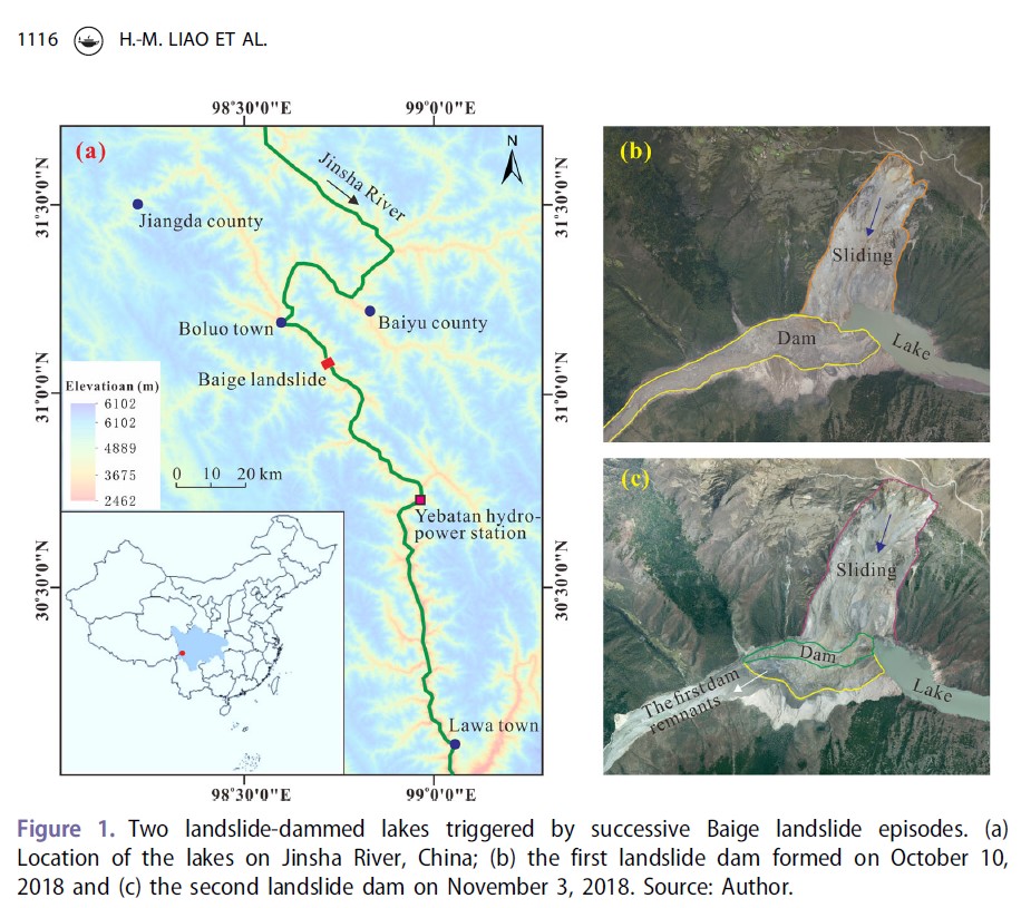
Not much of a thing is the equally dramatic events of October 2018 that, also in the dry season, dammed and then flooded two of the world’s greatest rivers, the Yangtze and the Yarlung Tsangpo/Brahmaputra, within two weeks of each other, both in Tibet, where drone cameras are available only to officials of the party-state and their footage is usually state secret.[4]
All three events have much in common: steep valleys carved by rivers powerful enough to cut deep, in pace with the ongoing rise of the Himalayas; glaciers perched far above on the upper flanks of the rising mountains, with a vertical gap between glacier and riverbed of two, three or more kilometres.
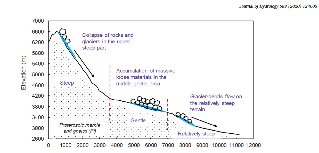
If a glacier starts to slide, it pushes ahead of it millions of tons of rock, mud and earth, gathering momentum, sweeping up the moraine boulders that had marked its furthest reach downhill in the pre-climate warm era of a few decades ago, sweeping through any high perch lake that had formed inside the moraine dam, gathering, gathering a formidable tribute to the overpowering force of gravity.
When millions of tons of mixed ice, water, rock and earth plunge kilometres down to the riverbed the event is catastrophic by any measure, as we all now see. No human initiative, on any scale, is remotely comparable. The Himalayas humble us, we engineer Himalayan rivers at our peril.
Once the human rescue hopes fade, what remains is the debate about causes and consequences. In democratic India, debate swiftly segued to arguments on the folly of hydro dams. On the silenced Tibetan side, no such debate is allowed.
So were these three catastrophes due to earthquakes, landslides or collapsing glaciers?
In landscapes as dynamic as the Himalayas, it doesn’t much matter which of these triggered the catastrophe. It could be climate change that was the trigger, as dry season cold is no longer cold enough to turn the summer rain and snowfall into solid ice that holds together the glacial mass and freezes the underlying lubricant water. It is striking that the sudden damming of both the Yarlung Tsangpo and Dri Chu/Yangtze happened in October, well after the monsoon rains receded, and the Uttarakhand outburst was in midwinter February.
In such unstable terrain riven by faults tearing in differing directions, an earthquake could have started the chain reaction. Either way, the laws of physics are at work, in the monsoonal skies, and deep in the rocks, and those forces -which Tibetan personify as local gods- need to be respected, and not ignored.
Whether glacier collapse, earthquake (big or small) or landslide came first doesn’t seem to matter much; the result escalates in minutes or seconds to something utterly beyond human comprehension.
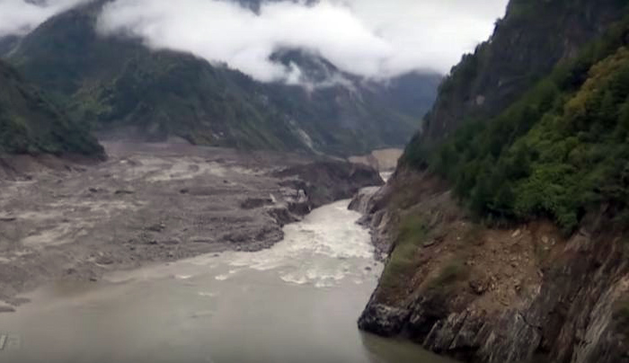
Equally, there is much confusion, in the initial aftermath of catastrophe. whether the wall of water smashing through the canyon happened right after the landslide/glacier collapse, or a little later. When millions of tons of mud, rock, ice and water crash into a narrow river valley, what usually happens is that it dams the river, and the river’s outflow banks up behind it, until the loose rockwall gives way, and suddenly collapses, and then the flood occurs. That is what happened twice in two weeks on the Dri Chu/Jinsha/Yangtze and Yarlung Tsangpo/Brahmaputra in October 2018. That is why geologists call this sequence a Glacial Lake Outburst Flood. There may be a few days between the crash and the flood, but nowhere near long enough for human intervention to make any difference, even if access to the site was possible, which is seldom the case. The only difference is that there may be enough time to warn those downstream that an outburst flood is likely; but that assumes the crash is monitored. It says much about the power of the Himalayas, and the depth its gorges cut, that on both sides of McMahon’s ridiculous line a crash of millions of tons of ice, water and rock can occur, and no-one even notices, until the flood happens.
Scientists do try to understand such events, typically it takes years. A similarly sudden glacial collapse in Amdo, northern Tibet, in 2016 saw two sudden glacial slides, gathering such speed they thundered downslope at 200 kms/hr. In a more arid landscape, there were few casualties. [5]
Little to none of the scientific analysis of these crashes was mentioned in the aftermath of the Uttarakhand disaster. Perhaps that’s because they were published in specialist journals, perhaps because in these polarised times Chinese scientists are not so popular. McMahon’s line continues to divide who is heard from who is ignored.
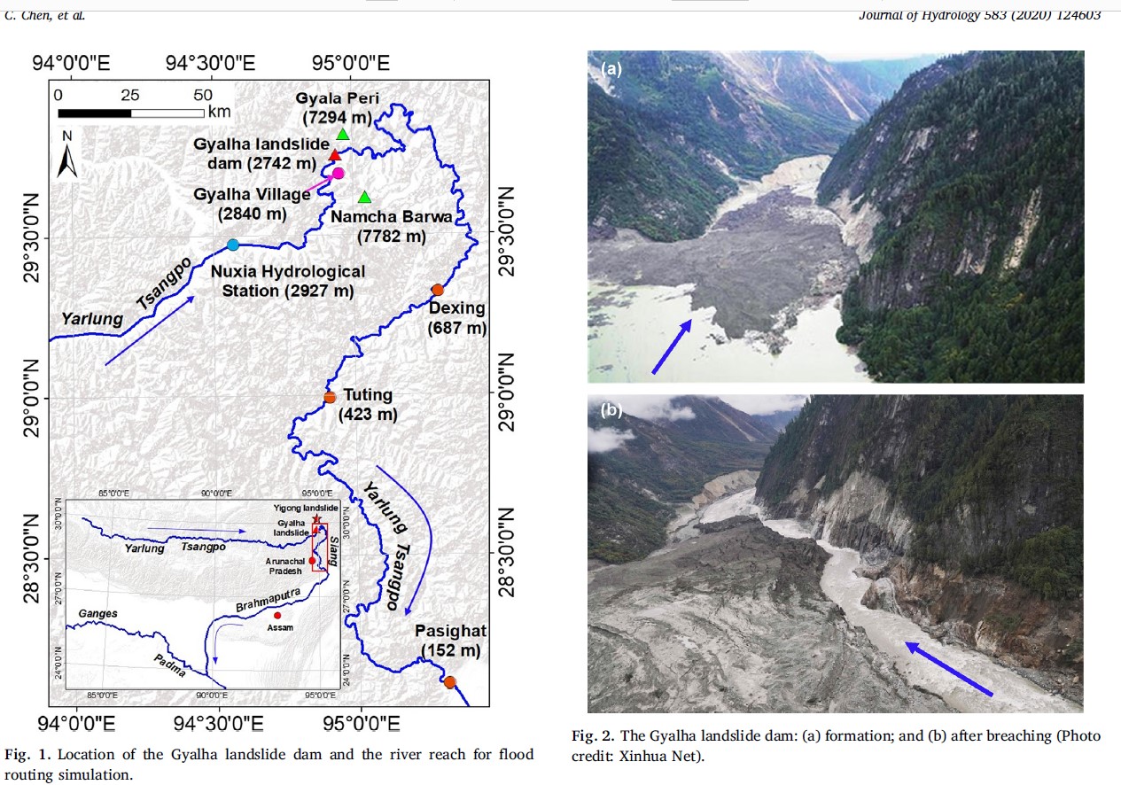
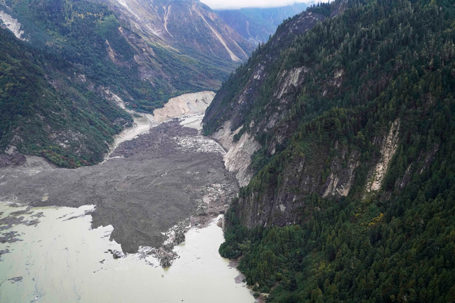
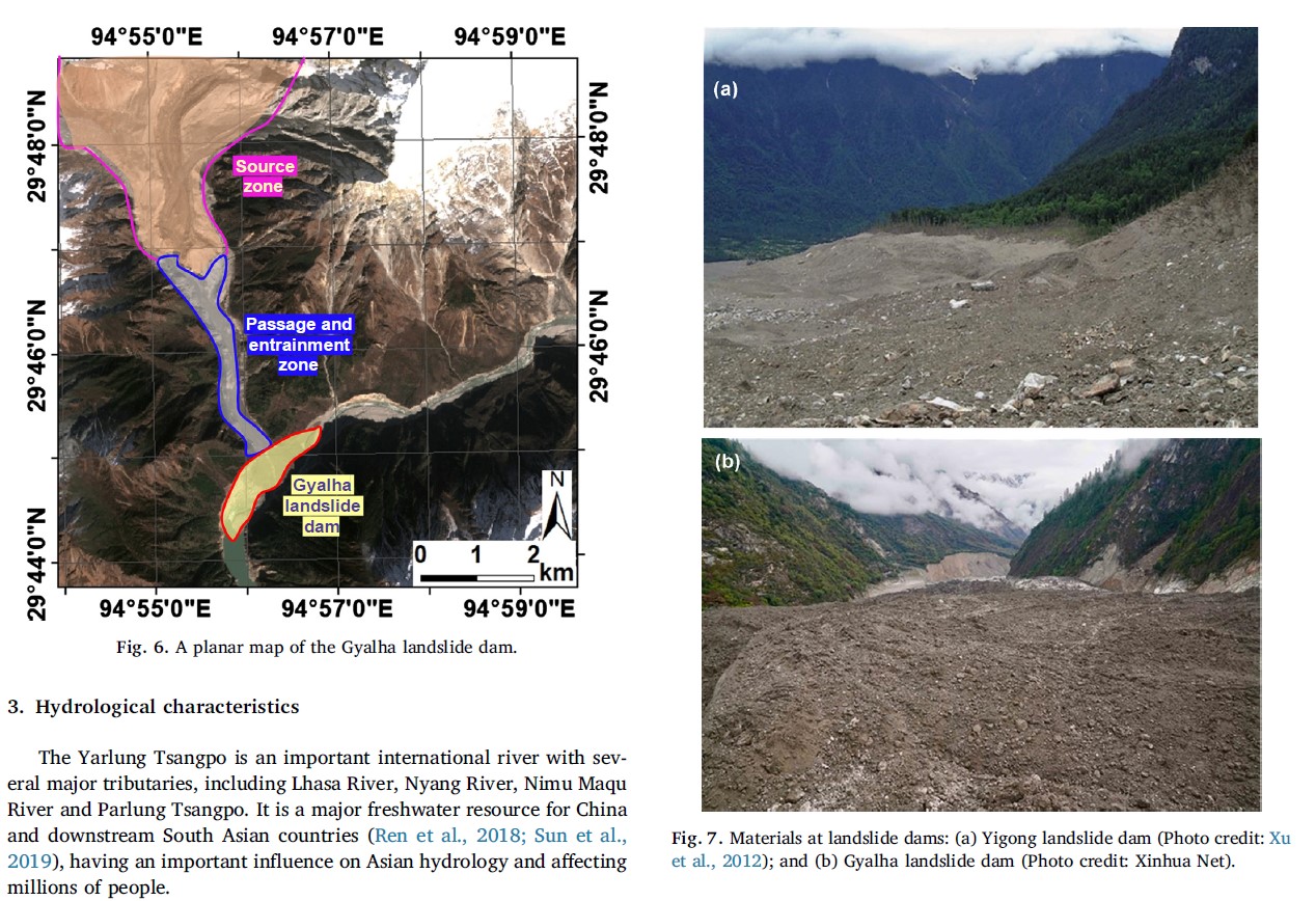
It is the Yarlung Tsangpo 2018 catastrophe that is most similar to Uttarakhand 2021, in that the leading tongue of a glacier perched far above the river collapsed in both cases. According to the Chinese scientists reporting the Yarlung Tsangpo GLOF, such events have happened before. Most of the scientists were from Hong Kong University of Science and Technology: “Ice-soil mixture landslide dams formed frequently in the Tibetan Plateau in response to global warming, which pose great threats to both upstream and downstream areas due to inundation and lake bursting. On 17 October 2018, a large landslide, induced by an ice-avalanche at the Sedongpu Basin of the Yarlung Tsangpo, blocked the main course of the river near Gyalha. The barrier lake level rose quickly, and the dam was overtopped naturally at 13:30 on 19 October 2018, generating a dam-breaching flood with a peak flow rate of 32,000 m3/s. This paper presents a comprehensive study of the disaster chain of landslide-barrier lake-dam breaching-river flooding in the Yarlung Tsangpo Grand Canyon, detailed geological and hydrological characteristics of the study region, rapid prediction of the dam breaching hydrograph using an erosion-based numerical model, and analysis of the flood routing in a 460 km canyon reach along the Yarlung Tsangpo.” It took only two days for the Yarlung Tsangpo’s post monsoon flow to build to the point of breaching a dam of millions of tons of rock, mud and ice. Is this what happened on the rivers of Uttarakhand?

On the Yarlung Tsangpo, the nearby Gyalha Peri mountain peak is well over 7000 m high, while the bed of the Yarlung Tsangpo below, at the point where the disaster occurred, is well below 3000m. The glaciers below the peak sit perched above the canyon, four kilometres above. That’s a long way to fall, an earthmoving in seconds that makes all human efforts at earthmoving puny by comparison.
The gap McMahon drew dividing the south face of the Himalayas from the north face, is a gift that keeps on gapping. In the absence of any interest or awareness of the Yarlung Tsangpo damming, journalists in India, needing to wrap this story, have focussed on the follies of hydro damming, even though the dams India builds on its Himalayan rivers (so far) are nowhere near as big as those China builds on the Yarlung Tsangpo and other rivers flowing from Tibet, including the Za Chu/Lancang/Mekong, and the Dri Chu/Jinsha/Yangtze.
Post-truth paranoia adds to the confusion, such as the story that a CIA nuclear powered monitoring device emplaced atop a nearby peak in 1965 caused the Uttarakhand catastrophe.
Indian environmentalists have been quick, as is possible in a democracy, to blame the hydro dammers; even suggesting Uttarakhand is a lesson China should heed, and not proceed with plans to build a 60MW dam in the Yarlung Tsangpo gorge.
Had the environmentalists, or the media reporting them, heard of the 2018 Yarlung Tsangpo crash, precisely in the very gorge where a 60 MW dam is mooted, the biggest dam in the world, they might have realised the 2018 crash, so similar to the 2021 crash, is the reason why such a dam can never be built. No dam, no matter how well engineered, can withstand tens of millions of tons of ice and rock falling from four or five kms above, at a speed faster than a bullet train.
As the glaciers wrapped round the peaks of Tibet now retreat, they protect the land of Tibet, and the Tibetan people, more than ever.
The standard metaphor of journalists and environmentalists is that the Himalayas are “fragile.” Not so. The Himalayas are powerful, and indifferent to human will. Tibetans have always known and respected this, and made frequent offerings to the local gods of place, burning smouldering juniper leaves every morning as fragrant smoke to please the gods.
Today, we put our faith in numbers, and the sciences that generate them; while the gods of place, the deities dwelling in the mountains are dismissed as superstition. We disseminate conspiracy theories about CIA mountain top monitoring devices, as we shelter under Henry McMahon’s great line, not keen on dispensing with fictions.
[1] Keay, John. The great arc : the dramatic tale of how India was mapped and Everest was named, HarperCollins, 2000.
[2] Sonika Gupta, Frontiers in Flux: Indo-Tibetan Border: 1946–1948, India Quarterly, Feb 2021
[3] John Keay, Home on a mountain range: A history of High Asia’s ‘snow abode’, Times Literary Supplement #6137, 13 Nov 2020
- [4] Chen Chen et al., Barrier lake bursting and flood routing in the Yarlung Tsangpo Grand Canyon in October 2018, Journal of Hydrology 583 (2020) 124603
- Limin Zhang et al., Erosion-based analysis of breaching of Baige landslide dams on the Jinsha River, China, in 2018, Landslides Journal, (2019) 16:1965–1979
- Yu-xiang Hu et al., Numerical simulation of landslide-generated waves during the 11 October 2018 Baige landslide at the Jinsha River, Landslides, 2019, 16
- Hongying Jia et al., Improved offset tracking for predisaster deformation monitoring of the 2018 Jinsha River landslide (Tibet, China), Remote Sensing of Environment 247 (2020) 111899
- Wentao Yang et al., Using Sentinel-2 time series to detect slope movement before the Jinsha River landslide, Landslides, 2019.
- Shi-lin Zhang et al., Initiation mechanism of the Baige landslide on the upper reaches of the Jinsha River, China, Landslides 2019
- Yulong Cui et al., A big landslide on the Jinsha River, Tibet, China: geometric characteristics, causes, and future stability, Natural Hazards 20202, https://doi.org/10.1007/s11069-020-04261-9
- Hai-bo Li et al., Mass movement and formation process analysis of the two sequential landslide dam events in Jinsha River, Southwest China, Landslides 2019
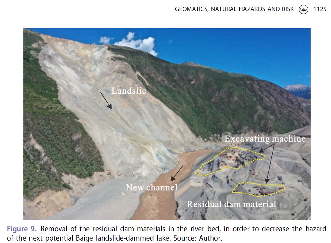
- Hai-mei Liao et al., (2020) Increase in hazard from successive landslide-dammed lakes along the Jinsha River, Southwest China, Geomatics, Natural Hazards and Risk, 11:1, 1115-1128
- Xuanmei Fan et al., Successive landsliding and damming of the Jinsha River in eastern Tibet, China: prime investigation, early warning, and emergency response, Landslides 2019.
- Hai-bo Li et al., Mass movement and formation process analysis of the two sequential landslide dam events in Jinsha River, Southwest China
[5] Andreas Kääb et al., Massive collapse of two glaciers in western Tibet in 2016 after surge-like instability, Nature Geoscience | VOL 11 | 114 FEBRUARY 2018 | 114–120
Adrien Gilbert et al., Mechanisms leading to the 2016 giant twin glacier collapses, Aru Range, Tibet, The Cryosphere, 12, 2883–2900, 2018.
4 replies on “CATASTROPHIC CLIMATE CHANGE”
[…] author of the book, “Spoiling Tibet: China and Resource Nationalism on the Roof of the World,” compared two different catastrophes, the Uttarakhand floods of February 2021 in India and the dramatic events of October 2018 that […]
[…] the e book, “Spoiling Tibet: China and Useful resource Nationalism on the Roof of the World,” compared two different catastrophes, the Uttarakhand floods of February 2021 in India and the dramatic occasions of October 2018 that […]
[…] author of the book “Tibetan Spoiling: Chinese and World Roof Resource Nationalism” Compared two different disastersThe Uttarakhand flood in India in February 2021 and the dramatic events in October 2018 flooded the […]
[…] of the book, “Spoiling Tibet: and Resource Nationalism on the Roof of the World,” compared two different catastrophes, the Uttarakhand floods of February 2021 in India and the dramatic events of October 2018 that […]