SACRIFICING TIBETAN RIVERS FOR CHINESE COAL
#2 in a series of 8 blog posts on China’s latest plans for Tibetan rivers
BIG COAL’S BIG THIRST
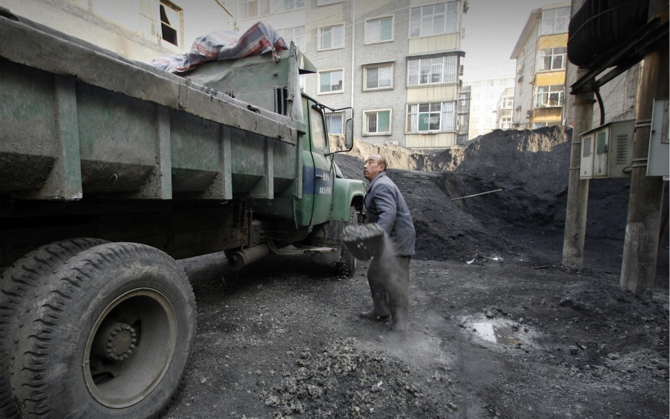
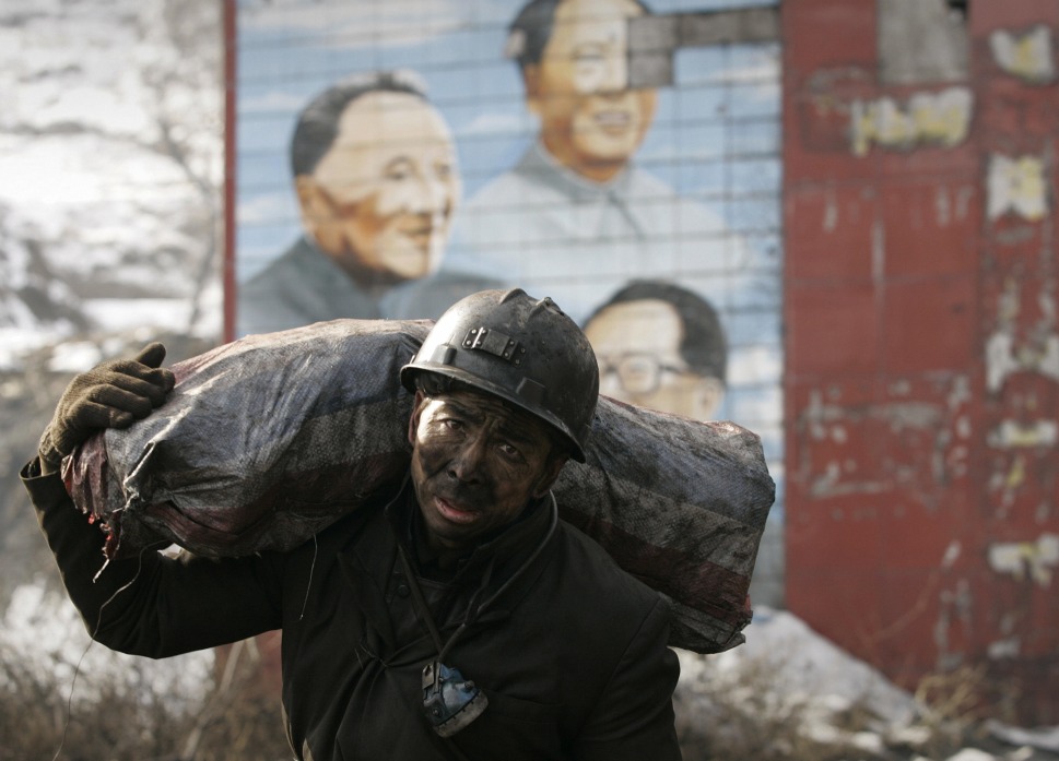
All stages of coal production require water. At the coal face, if workers are to avoid black lung disease, dust is suppressed with water. Coal stored above ground is susceptible to catching fire, and is washed with coal, for dust and fire suppression. When coal is burned to generate electricity massive cooling towers must be installed, emitting constant clouds of steam, as water is the cheapest coolant. When coal is converted to coke, for steel making, water is needed. When coal is gasified to make a new fuel to be piped to cities, water is needed. When coal is converted into a wide range of chemicals -a major goal of the 13th Five-Year Plan- much water is used and of course dirtied.
So the diverted waters of Tibet will not be used to grow lowland China’s crops or provide potable drinking water for urban folk; its main use will be in the coal industry. That is the argument made by advocates of the south-to-north S2N Western Route, based on who can pay sufficient prices to justify the project. It seems especially sad that the rivers of Tibet are to be captured and diverted only to perpetuate China’s addiction to coal.
That is the argument of one of China’s leading water engineering analysts, Prof. Jia Shoufeng, Deputy Director of the Center for Water Resources Research under the Chinese Academy of Sciences (CAS), Chair of the Department of Water & Land Resources Research at the CAS Institute of Geographical Sciences and Natural Resources Research, and Vice Chair of the Special Committee for Water Resources under the Hydraulic Engineering Society of China. Prof Jia argues that if S2N Western Route is implemented, at least in part, there will be enough water for China’s many coal mines, coal-fired power stations and coal chemical factories to obtain the water they badly need. He calls these coal-based industries based in Shanxi, Shaanxi, Inner Mongolia, Ningxia, Gansu and Qinghai China’s primary energy supply base, now and well into the future.
Citing Ministry of Water Resources estimates, he says the energy supply base needs no more than three billion cubic metres (3bn m3 ) of extra water, to enable them to not only keep functioning but to expand and fulfil a 13th Five-Year Plan goal of large scale conversion of coal to gas to be piped to users.[1]
China’s use of coal has become globally controversial because of the resulting climate warming emissions. There is much confusion around actual coal use, with China and environmentalists worldwide reporting hopefully not only a peak in coal consumption but even a decline in coal use. [2] However, China officially does plan to increase its coal use, well beyond the current level of 3.8 billion tons a year, already more than half the global total, and China has approved the construction of many more coal-fired power stations. All China agreed to at the Paris global climate treaty negotiations in 2015 was that coal use would peak in 2030 and then start to decline. The actual 13th Five-Year Plan specific target for coal consumption in 2020 is 4.3 bn tonnes.[3]
据西安的环保部门的消息,西安西郊工业集中区大气污染专项整治已经启动,期间将完成对西安焦化厂的关闭工作。西安焦化厂关闭后,将年削减3亿立方米废气,减排烟尘、粉尘1500吨。
Since coal is mostly found in the arid north, and electricity demand is mostly far to the south and east, the energy base contains many industrial complexes with dozens of uses for coal. All need water. Prof Jia disagrees with the international NGOs working in China, which have generated much higher estimates of how much water the coal industrial complex needs.[4] He reanalyses the concerns expressed by Choke Point China, a project of the Woodrow Wilson Center and the NGO Circle of Blue; also the estimates of Greenpeace, and Hong Kong based China Water Risk. According to Prof Jia they all greatly exaggerate how much water the coal industries need.
His own estimate, of 3bn m3 dovetails well with the planned pumping of water, in the third of the three S2N Western Route plans, the diversion of the Dadu River. He advocates that some or all of S2N Western Route goes ahead, because the coal industry can and will pay a sufficiently high price for Tibetan water: “Building the Western Route of the South-North Water Transfer Project can be considered. The key to the success of inter-basin water transfer projects is whether there are water users that could afford the relatively higher cost of ‘transferred water’. The reason why some water diversion projects haven’t commenced as planned is mainly because high project costs result in high water prices and there are currently not enough users who can afford to pay the price. For the Western Route, the energy industry will be the main user and these users can afford to pay the higher water prices. It is clear that energy companies can afford the relatively higher price of ‘transferred water’.
“Moreover, the Western Route actually comprises several smaller-scale water transfer projects which can be implemented through several phases. The water sources of the Western Route include three rivers with total annual runoff of 22.1 billion m3: the Dadu River at an altitude of 2,900m, and the Yalong River & Tongtian River at 3,500-3,600m. According to the preliminary plan, the annual average transferable water from these three rivers is 12-17 billion m3: 3-5 billion m3 from Dadu, 3.5-4 billion m3 from Yalong and 5.5-8 billion m3 from Tongtian.
“The first phase of the project can be implemented in the three tributaries of the Dadu River, namely Ake River, Ma’er River and Duke River as these lie closer to the Yellow River; about 3-5 billion m3 can be transferred. If the development of the energy bases is really suffering from water shortage, water transfer from the Dadu River of around 4 billion m3 to the Yellow River can be implemented first. Once implemented, it will not only meet water demand from energy bases, but also supply water for industrial and municipal use.”[5]

Prof Jia favours the Dadu River diversion being built first, even though, of the three S2N Western Route big reservoirs, it is the one that defies the laws of gravity, and requires the pumping of billions of cubic metres of water uphill, by 458 m up, to be precise. That enormous burden of pumping will, in turn, necessitate more hydro dam building in Tibet as well, to generate sufficient electricity. For Prof Jia this is not a problem. His focus is on finding a way to get the S2N Western Route built, and he is cheerfully confident he has found the clincher, in the coal industries: “Perhaps together, the development of energy bases along the middle and upper reaches of the Yellow River and the construction of the Western Route, can achieve a win-win!”
Jia Shoufeng and other advocates of capturing Tibet’s rivers make light of the water demands of the coal industries, but other sources suggest China’s ongoing reliance on coal will need not only one but all three of the S2N Western Route big reservoirs and tunnels. China Water Risk evaluates the energy industry’s demand for water: “Power generation is heavily reliant on water for cooling purposes as well as driving steam turbines. The power sector is the 2nd largest user of water in China after agriculture, making it the No.1 industrial user of water. Coal generates over 16 per cent of China’s GDP, making it the biggest of China’s industries.[6]
Not everyone is so optimistic. A 2015 report by China Water Risk, of 200 pages, Towards A Water & Energy Secure China: Tough Choices Ahead In Power Expansion With Limited Water Resources, suggests access to water remains a severe constraint on China’s many coal-based industries.[7]
“Electricity consumption in China has almost quadrupled over the past decade from 1,347TWh in 2000 to 4,976TWh in 2012. Industry drives the nation’s hunger for power, with 85% share of electricity consumption. China is still hungry for thirsty power and could add 2TW by 2050. This is more than the current total installed capacity of the US, UK, France, Germany, Russia and Japan combined. Concerns over China’s power expansion are not whether the build out can be achieved but whether China has enough water resources to fuel this expansion. The power sector’s water risk exposure is great.”
China’s coal industry, manufacturers using coal coal-fired electricity to turn raw commodities into marketable metals or chemicals, and the transport network that hauls coal from mines to industrial consumers are all subsidised, encouraging further coal use.[8] Contrary to popular rhetoric of a green China, perverse incentives persist, that add to fuel consumption, greenhouse gas emissions and the need to capture Tibetan rivers.
In 2015 Lord Nicholas Stern issued a plea for China to start to at least scale back approvals for new coal-fired power stations, and in the 13th Five-Year Plan to not promote conversion of coal to gas, as other sources of cleaner gas are readily and cheaply available. Professor Stern’s plea got nowhere and coal gasification is now a priority of the 13FYP. Stern proposed: “strictly limiting approvals for, and investments in, new coal plants— unless these are strictly necessary to replace older and less efficient capacity — will be needed to curtail these economically inefficient expansions. Such action is strongly warranted for economic and financial reasons, let alone environmental, public health and climate reasons. In the case of coal bases and coal-to-gas plants, a strategic decision, reflected in the 13th Five-Year Plan, not to prioritise and support such developments, along with specific regulatory controls, would be consistent with achieving the kind of structural change, better growth and early peaking of emissions at the core of China’s new development model.”[9]
Greenpeace reported that provincial authorities in China, in 2015 have issued permits for 210 new coal-fired power stations to be built, and of these: “49% of the power plants are in areas with extremely high water stress, 5% in high water stress areas and 6% in arid areas. The power plants in these very water stressed areas would consume at least 310-370 million cubic meters of water every year, equivalent to the needs of roughly 5-6 million urban dwellers, exacerbating the conflict between urban, agricultural and industrial water use.”[10]
If China persists in relying so heavily on coal, the alternative strategy would be to strictly regulate the use of water by the coal industry, and the Ministry of Water Resources (MWR), in 2013, attempted to do so.[11] The political reality is that MWR has no real power over a coal industry that often defies Beijing altogether, with innumerable illegal (and highly dangerous) coal mines. MWR in practice has been largely ignored. Rather than managing water demand, the solution is, as usual, to increase supply, this time from Tibet.
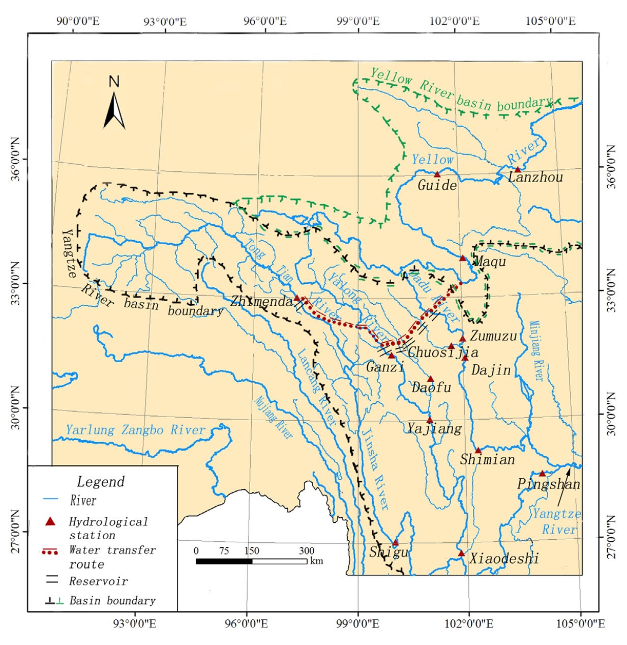
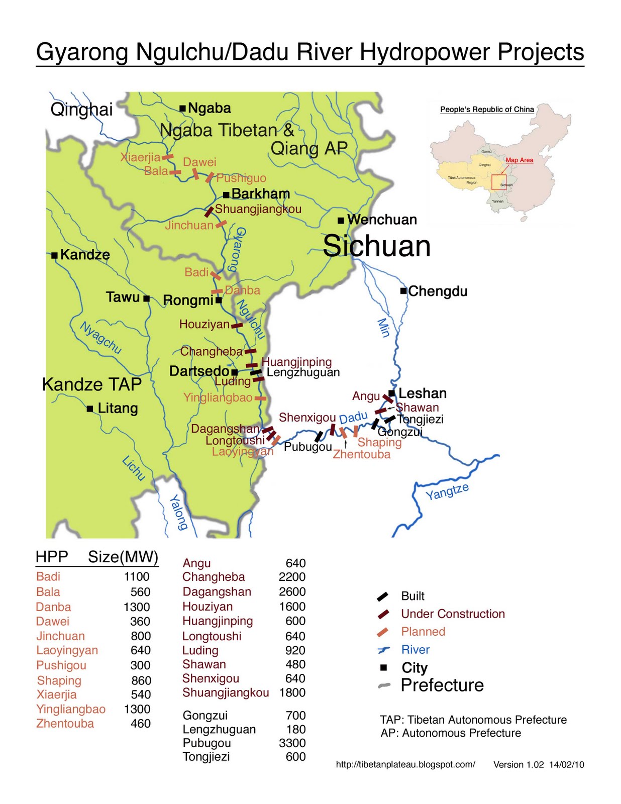
A CLOSER LOOK AT THE ACTUAL WATER DIVERSION PLAN
The first route officially due to be constructed is a dam 175 metres high intercepting the Dza Chu (Yalong) river at Throshul Gongma (~32°10’N, 98° E). The tunnel is mapped as a straight line heading northeast, under the Bayan Har range (巴颜喀拉山脉, Bāyánkālā shānmài, in Tibetan: Mardza Gang), then continuing underground, to debouch in Amdo Golok (Qinghai Guoluo in Chinese) near the villages of Barshi, Palyul, Darhang and Menkarhang, (~32°50’ N, 99°45’ E) on a minor tributary which flows north into the Yellow River. The outlet will be in Pema Dzong (Banma Xian [county] in Chinese) or in Darlag Dzong (Dari Xian in Chinese), both remote pastoral districts with, until now, very few immigrant Chinese and by census count 93% and 96% Tibetan respectively, populated almost solely by Tibetans. The added dam wall height of 175 m just overcomes the 80m height increase of the end point over the start point, but will greatly limit how much water can be released from the big reservoir, if gravity is the sole flow driver. The tunnelling for the entire 131 kms, will have to be remarkably accurate.
This is well upriver, before the Ma Chu (Yellow) skirts the flanks of the sacred Amnye Machen range and then slows greatly, fanning out across the Dzoge wetland and water meadow lands now recovering from modernist projects to separate water and land into mutually exclusive categories by draining the “swamp” with ditches. How these peatlands and wetlands will cope with many billions of cubic metres of extra flow is not clear.
The extra flow will be a maximum of five bn cubic metres, only one quarter of what the entire project of three reservoirs and three tunnels are meant to deliver. Thus the second stage, even further up the Yalong river, is to boost the Yalong with a further 10 bn cubic metres of water to be withdrawn from the main channel of the Dri Chu (Yangtze), not long after the Dri Chu exits Qinghai below Yushu and enters the northwesternmost end of Sichuan.
This project cannot be built until the first project, that actually delivers water flow into the Yellow River, is operational. If the second project existed by itself, all it would achieve would be to send water from one tributary of the Yangtze to another, eventually returning to the same outflow. But the second stage is supposed to deliver as much as half of all the water of the three projects combined, a total of 10 bn m3 , even though most rain falls in the summer monsoon season, and north China’s water shortage is worst in winter –another reason for big reservoirs retaining vast amounts of impounded water (and sediment).
The second project is even more ambitious than the first, with a tunnel length of 158 kms, and a dam wall height of 302 m, a very high dam, second highest in the world. The Dza Chu/Yalong is actually closer, approximately 70 kms, but the length of the tunnel is much greater. Of the many problems China’s planners have had to grapple with is the basic reality that even in the uppermost reaches, the Yangtze is a bigger river than the Yellow, and has, over millions of years, therefore cut deeper, incising itself into the Tibetan Plateau, so even when the rivers run parallel, the Yangtze is lower. Extremely long tunnels are the engineering answer. In order to find an entry point into the Yalong that is below the intake on the Tongtian/Yangtze/Dri Chu, 90 extra kms of tunnelling will be needed just to achieve a gravity drop and avoid pumping.
The second reservoir, with its 302 m high dam wall, is in a deep valley just below the confluence of the Dri Chu/Yangtze and the Chumarleb river (32°40’, 96°E). The area receives only 400mm of rain (or snow) a year, the catchment further upstream less still.[12] It is not far below the new national park proposed for Drito county (Zhiduo in Chinese), the proclaimed source of the Yangtze, its Tibetan name signifying that Tibetans have long known it at the source of the Dri Chu/Yangtze. Does a national park, ostensibly dedicated to honouring the source of the Yangtze, and to carbon capture by excluding nomadic pastoralists to grow more grass, fit well, immediately downstream, with a massive dam to capture the waters of the Yangtze and send them to northern China? Protection and extraction in one landscape?
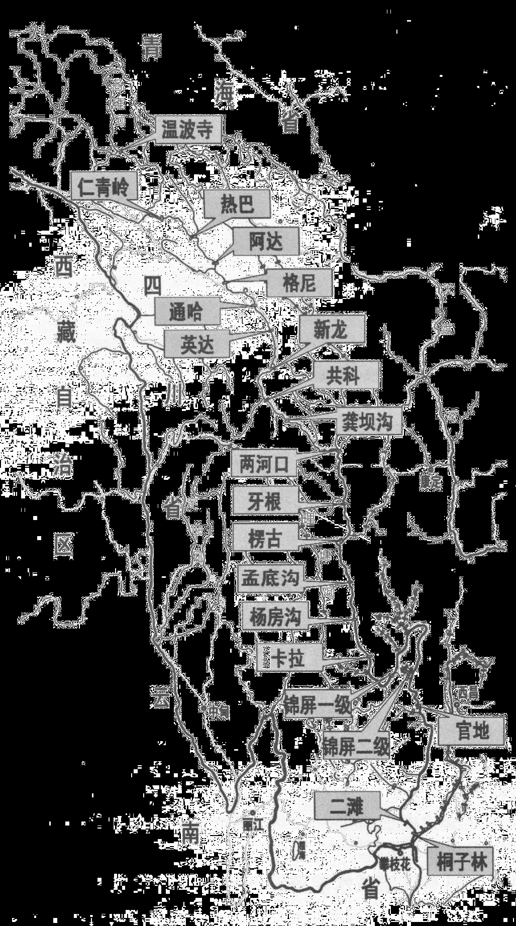
The third of the three big reservoirs in the package listed officially under the South-to-North Western Route Water Diversion scheme is quite different, in location, and in its disregard for the law of gravity. On the Dadu River (Chinese) another “big reservoir” is planned. The official description states: “The Hydraulic Project will be constructed on Xierga Reach of Zumuzu River, a tributary of the upper reach of Daduhe, the height of the dam is 296 m. The water by pumping will be diverted from Xierga Hydraulic Project to Jiaqu River, a tributary of Huanghe, total length of the diversion route is 3O km, including a 28.5 km tunnel. The lifting height of the pumping station is 458 m, the mean annual power consumption is 7.1 billion kwh.”
The plan is for four hydropower stations, known in Chinese as Xiaerga, Bala, Dawei and Busigou, on this tributary of the Dadu River, with the big reservoir at Xiaerga above them. All the power they generate by capturing the energy of this mountain river will be needed to pump water uphill, through almost 30kms of tunnel.
The great attraction of this project is that at this point the Yangtze and Yellow Rivers are remarkably close, though separated by the Bayan Har (Mardza Gang in Tibetan) mountain range. Yet along the planned tunnel alignment Chinese geophysicists have found five fractures, five faults and one abnormal zone in the eastern portion of the tunnel, and a further two fractures, three faults and four abnormal zones in the western section of the tunnel.[13] The dam wall height, of 296m, will make it the third highest dam worldwide. But the distance is only 30 kms, from a tributary of the Dadu to a tributary of the Yellow River.
“Bala power station, with a maximum height of 138 m, is a high-dam hydropower station that is to be constructed on the Zumuzu River, source of the Daduhe River. The backwater length of Bala Reservoir under normal water level is 26 km. At the upstream end of Bala Reservoir, a controlled cascade, Xiaerga Dam, is in the planning stages. The maximum height is 242 m. The main discharge structure is a spillway. The dissipater of the spillway is designed as a ski-jump type model.”[14]
Another recent definition of what is to be built lists more dams: “The South-to-North Water Transfer Project is an extremely important infrastructure project to ease water shortage and meet the development requirements of northwestern and northern China. An earlier study on the project began in the 1950s. The Western Route Project (WRP) can control the water distribution to northwestern and northern China and meet the water demand of six provinces and their neighboring regions in the next 50 years. Furthermore, the WRP will improve the management of the Yellow River and promote the development of the cities in the Yellow River basin. The WRP may bring enormous social, environmental, and economic benefits. The WRP will be completed in two stages and in the first stage 8 x10⁹ m3 [8 bn cubic metres] water will be transferred from the upper reaches of the Dadu and Yalong Rivers, in which Dadu River contributes to 2.35 x10⁹ m3 [2.35 bn cubic metres] , accounting for 5% of the annual runoff of the river. According to the layout of the WRP, four dams will be built in the four tributaries of Dadu River: Keke dam in Ake River, Huona dam in Make River, Zhuanda dam in Duke River, and Luoruo dam in Sequ River. The annual diverted water amount in the four tributaries are 0.35 billion m3 , 0.75 billion m3 , 1 billion m3 , and 0.25 billion m3 , respectively.”[15]
What China’s planners and engineers call the Ake River is to Tibetans the Nga-chu, a tributary of the Mar-chu. The Nga-chu in turn creates the name of the county and its town, Ngawa, in Chinese Aba, which under China has become the name of the entire prefecture, traditionally part of Amdo, now the northernmost portion of Sichuan. The Chinese names for the dams are sometimes taken directly from the Tibetan, such as Bala, a monastery of the Jonangpa school of Buddhism.[16] From China’s perspective the area is at the junction of three provinces: Sichuan, Qinghai and Gansu, remote from the distant lowland capital cities of each. For urban elites based in Beijing, Chengdu, Xining or Lanzhou, these are mountain waste lands that have never produced anything entered into national accounts.
ENVIRONMENTAL CONSEQUENCES: CAN A RIVER DROWN?
It is not possible to tip as much as 20 billion cubic metres of water into a tributary of the Yellow River, far upstream, without consequences. This is especially so because rainfall is concentrated in a few summer months, and even with the planned “big reservoirs” holding back water as long as possible, outflow will still not be spread evenly.
For the Yellow River, an extra 20bn m3 effectively doubles the size of the river, at the point of entry. This in turn has major consequences further downstream. The Ma Chu/Yellow River/Huang He, a little further down, is pushed towards the southeast by the sacred Amnye Machen range, all the way along the southern flank, to its end. Eventually the river then loops back to flow along the north side of the Amnye Machen range before heading further north. But once it is no longer hemmed in by the south side of the Amnye Machen mountains, the Yellow River does something remarkable: it fans out into a vast water meadow, a cold but fertile pasture of rich tussock grasses and water, fed not only by the main stream of the Yellow River but by other tributaries coming in from the east.
This is the great Dzoge wetland, one of the biggest and highest wetlands in the world, partly protected by the Ramsar global wetland protection treaty, and listing on the World Database of Protected Areas, and now recovering from China’s campaign to drain it.
The developmentalist state, from the north German plain in the 19th century to modern China, abhors this mixing of land and water. While Tibetan pastoralists and their yaks knew how to walk from tussock to tussock without bogging, modernisers feel compelled to separate earth and water, each in their separate domain, as a prerequisite for intensifying production. China dug innumerable channels and ditches to drain Dzoge, exposing to the air organic matter accumulated over thousands of years as the sedges and grasses flourished, died and were compressed into peatland. Once exposed, the peat is susceptible to fire, to slow, smoky, ineradicable burning.
In recent years, China has recognised that draining the Dzoge wetland was a mistake, and has started filling in the ditches, in the hope of repurposing the area as a major ecotourism attraction.
If 20bn m3 of water comes down the Yellow River, this will transition the drying wetland in the opposite direction, inundating it.
The Ramsar convention lists what is at stake: “Sichuan Ruoergai Wetland National Nature Reserve. 02/02/08; Sichuan; 166,570 ha; 33°43’N 102°44’E. Nature Reserve. Said to be the largest alpine peat marsh in the world as well as tundra wetland located in the upstream area of the Yellow River and the northeast of Qinghai Tibet Plateau at 3,422m-3,704m altitude. A marsh meadow vegetation provides habitat for 137 bird species including IUCN Red-List species Chai (Cuon alpinus),Yudaihaidiao (Haliaeetus leucoryphus), and Heijinghe or Black-necked Crane (Grus nigricollis), as well as 38 animal species, 3 amphibian species,15 fish species, 3 amphibian species and 362 wild plant species. The site is also referred to as the water tower of China, as it serves the important water supply area of upper Yangtze River and Yellow River. The site stores peat of 7 billion m3 and has water-holding capability of nearly 10 billion m3. It contributes to local climate regulation, water and soil conservation, and aids in reducing green house effects. A high touristic place with a unique ecosystem, panoramic plateau landscape, and colorful Tibetan culture with great aesthetic value. Desertification and decrease in marsh area have occurred due to global warming and rainfall reduction.”
[1] http://www.china5e.com/index.php?m=content&c=index&a=show&catid=13&id=941066
[2] Coal Cap Policy Can Help China Achieve an Earlier Peak in Carbon Emissions
http://www.nrdc.cn/coalcap/index.php/English/project_content/id/570
[3] http://www.china5e.com/index.php?m=content&c=index&a=show&catid=13&id=941390
[4] http://www.greenpeace.org/international/en/publications/Campaign-reports/Climate-Reports/The-Great-Water-Grab/
[5] Jia Shaofeng , Will Energy Bases Drain the Yellow River? China Water Risk, February 10, 2015, http://chinawaterrisk.org/opinions/will-energy-bases-drain-the-yellow-river/#sthash.SVg2VDcS.1tpReJo6.dpuf
[6]申宝宏 Shen Baohong, Scientific mining capacity and sustainable development for coal sector, 4 Nov 2015
[7] http://chinawaterrisk.org/notices/towards-a-water-energy-secure-china/
[8] Doug Koplow et al., Untold Billions: Fossil-Fuel Subsidies, Their Impacts And The Path To Reform: Mapping The Characteristics Of Producer Subsidies: The Global Subsidies Initiative, IISD, 2010, 31-36
[9] Fergus Green and Nicholas Stern, China’s “new normal”: structural change, better growth, and peak emissions, Grantham research Institute on Climate Change and Environment, Policy brief July 2015,
[10] Lauri Myllyvirta, Xinyi Shen, Harri Lammi; Is China doubling down on its coal power bubble? Over 150 new coal-fired power plant projects being permitted in China. Greenpeace http://www.greenpeace.org/eastasia/publications/reports/climate-energy/2016/coal-power-bubble-update/
[11] http://chinawaterrisk.org/notices/mwr-announces-for-coal-plan/
[12] Annual precipitation of China, map 30 in Geographic Atlas of China, (Zhongguo di li tu ji) Beijing 2009
[13] DI Qing-Yun WANG Guang-Jie GONG Fei et al., Geophysical Exploration Of A Long Deep Tunnel On The West Route Of South-To-North Water Diversion Project, Chinese Journal Of Geophysics’地球物理学报 Vol.49, No.6, 2006, Pp: 1676∼1683
[14] J. Feng, R. Li, R. Liang, and X. Shen, Eco-environmentally friendly operational regulation: an effective strategy to diminish the TDG supersaturation of reservoirs, Hydrology and Earth System Sciences, vol 18, 1213–1223, 2014
[15] Shimin Tian , Zhaoyin Wang, Bimodal Sediment Distribution And Its Relation With The River Ecology In The Dadu River Basin, Proceedings of 16th IAHR-APD Congress and 3rd Symposium of IAHR-ISHS, Springer, 2009, vol 2, 1049-1054
[16] Gyurme Dorje, Tibet Handbook, 787