EVALUATING CHINA’S NOMINATION OF HOH XIL NATURE RESERVE TO BECOME A UNESCO WORLD HERITAGE NATURAL PROPERTY
#2 of a series of 3 blogs
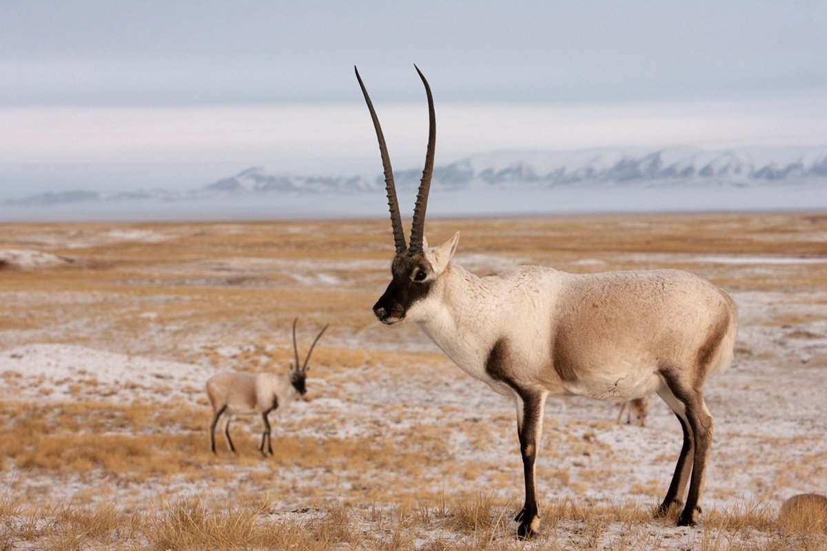
THE ICONIC CHIRU ANTELOPE
In celebration of the heroic efforts of Tibetan guardians of the chiru antelope, China produced not only the very popular movie Kekexili: Mountain Patrol but, in 2004, a handsome full-colour English language book Tracking Down Tibetan Antelopes, which reminds us that: “Within a century, the number of Tibetan antelopes plummeted sharply from about one million to fewer than 100,000, and dangerously close to extinction.”[1] The author, Wang Lei, is one of the Han Chinese who saw for themselves, in the high alpine desert, how Tibetans risked their lives to protect the last chiru. Wang Lei is a graduate of the elite Beijing Drama and Literature Academy, turned conservationist. Her writing is a screenplay, with the Tibetans of “no-man’s land” centre stage: “Once asked if he worried about his personal security, Soinam Darje said, ‘The Hoh Xil issue may not attract adequate attention without loss of life. If people have to die for this, let me be the first.’ On January 18, 1994, the temperature dropped to 40 degrees below zero in Hoh Xil. The team was on patrol and arrested the poachers. The team confiscated 2000 chiru hides. Since one poacher was suffering from pulmonary edema, a fatal illness at high altitudes, Soinam Darje assigned two colleagues to escort him and a few wounded poachers back to Golmud. He and another colleague set out later. The poachers overpowered the other guard and shot Soinam Darje dead.”
Movie director Lu Chuan, with his film Kekexili (pinyin Chinese for Hoh Xil) made his reputation as a director of action movies in remote locations, culminating in his recent return to Tibet for the Disney doco Born in China, which follows three families of chiru and snow leopards, and, in the foothills of the Tibetan Plateau, a panda family. Born in China is due for release April 21, 2017, but Disney has previews available, showing Lu Chuan’s gift for stunning landscapes.
Lu Chuan directed five movies since Kekexili made him, aged 33 in 2004, high profile both in China and around the world. Although he managed to shoot on a small budget, Kekexili is professionally made, with its $1.2 million budget supported by Columbia Pictures, Warner Entertainment and Canon.
A popular feature movie showing China unable to enforce its laws, against barbaric slaughter, leaving effective protection in the hands of a bunch of unwashed Tibetans, was an embarrassment then, and in today’s highly authoritarian China, it is unimaginable that major studios would fund a movie that could be seen as admitting China has failings and authority is inadequate. Although Hoh Xil was first declared a nature reserve in 1995, the success of Kekexili the movie ensured Hoh Xil got national regulatory attention.
Chiru depicted on a flat desert landscape constitute China’s image of Hoh Xil, and feature on the stamps China issued to celebrate its “conquest” by rail of the Hoh Xil “no-man’s land’ (无人区 wurenqu). It is all about the chiru, and not any local human communities. A cute, sentimental cartoon baby chiru was a mascot of the Beijing Olympics in 2008. The chiru has achieved more than iconic status. It is a surrogate for the urban yearning for something to believe in. The rise of the chiru was accompanied, in the same Olympic year, by the demonisation of the Tibetans in China’s mass media, endlessly depicted as hating all Han Chinese, seeking only “looting, smashing, burning and killing.”
MINING
On the ground, China’s laws forbidding mining in nature reserves did not always mean that local causes of land degradation ceased. Of the many areas of the Tibetan Plateau where illegal gold mining had flourished for years, some were in Hoh Xil, notably Mato, where there was a gold rush, with swarms of poor immigrant peasants from lowland Chinese provinces seeking their fortunes in the rivers China now swears to protect. Alluvial seekers of placer gold chewed up river beds and river banks, sluicing for specks of gold, leaving much destruction, with no accountability or concern for consequences.
According to a comprehensive survey, county by county, published in 1997: “In 1989 a large gold deposit was discovered in Tridu County, the largest gold reserve found in Qinghai province up to that time. The most thorough mining activities in the [Yushu] prefecture, at least in recent years, appear to have taken placed in Chumarleb County, apparently since 1988. The official publication Legal Daily reported 50,00 to 60,000 Chinese gold miners working there, resulting in damage to 86,000 acres of grazing land in the county.”[2]
In the Changtang nature reserve official geological prospecting parties in 1989 found a major gold deposit in Shentsa county, 90 kms SW of the county town, at the confluence of two seasonal rivers, the Bengna Tsangpo and Baru Tsangpo.[3] After drilling 5700 boreholes, the geologists reported a total amount of recoverable gold of 10 to 15 tons, worth $400m to $600m at 2016 prices. The geologists proudly announced: “the deposit is regarded as the largest ever found in Tibet and is also rare in the country. This, as a good beginning in Tibet’s history, made a breakthrough in the geological work of gold in Tibet.”[4]
The same volume of geological exploration success also records several deposits of boron in the Changtang, a mineral in great demand in the era of Sino-Soviet friendship, for moderating nuclear reactions in Soviet nuclear facilities.
This volume also records a substantial find of amethyst crystal in Palgon County, in the Changtang nature reserve.[5]
Recently shale oil has been discovered in the heart of the Changtang nature reserve. [6]A major factor determining whether extraction is feasible is to study what toxins are released when the oil is combusted for its energy. Changtang shale been carefully tested, and found to have alarmingly high levels of toxic arsenic and cadmium. [7] Extraction of shale oil means fracking, which injects huge amounts of water deep into the oil layer, in an area that is arid.
All of these finds confirm the overall picture of the geologists, that the long west-east trend of the mountain ranges, river valleys are the result of the subduction of one plate under another, a process that, through intense pressure and heat rising from deep below, generates concentrations of minerals. Both the Changtang nature reserve and the Hoh Xil nature reserve are on this long suture zone, making it likely there will be many more mineral finds. The best known suture zone in Tibet is further south, the long valley of the Yarlung Tsangpo river, similarly west to east, also caused by subduction (of the Indian plate) and collision of continents. Most of the major mineral deposits found, and exploited in Tibet, especially the big deposits containing copper, gold, silver and molybdenum, are on this suture zone.
On paper, exploitation of mineral deposits is incompatible with nature reserve status, and is illegal. In practice, as George Schaller has noted privately, there is active mining in many of the nature reserves he helped establish in Tibet.[8]
THE STATE TAKES OVER
China’s regulations can be used in a wide range of circumstances to achieve different policy objectives. When, in the early 1990s, the Changtang nature reserve was established, covering 298,000 sq. kms, all concerned could agree that protecting an alpine desert where Tibetan gazelles and antelopes migrate annually to breed, a huge area with very few human inhabitants, was good.
The Changtang, Hoh Xil and Sanjiangyuan nature reserves fit together like jigsaw pieces,[9] one continuous ribbon stretching from west to east (upper to lower) for almost the entire span of the whole Tibetan Plateau, and across two provinces: Tibet Autonomous Region and Qinghai. The ribbon is close to 1900 kms long, and north-to-south of varying width, between 140 and 350 kms wide.
The total area is 495,000km2, a little smaller than all of Spain. What does this enormous span have in common, marking it as a natural category for conservation, and little else? Since it stretches from the stony deserts of upper Tibet in the far west to the verdant pastures of the well-watered far east, from low to high population density, from a land of lakes which have nowhere to drain, to the headwaters of three of Asia’s greatest rivers; it is hard to think of anything all these production landscapes have in common, requiring their conservation, largely to the exclusion of human use.
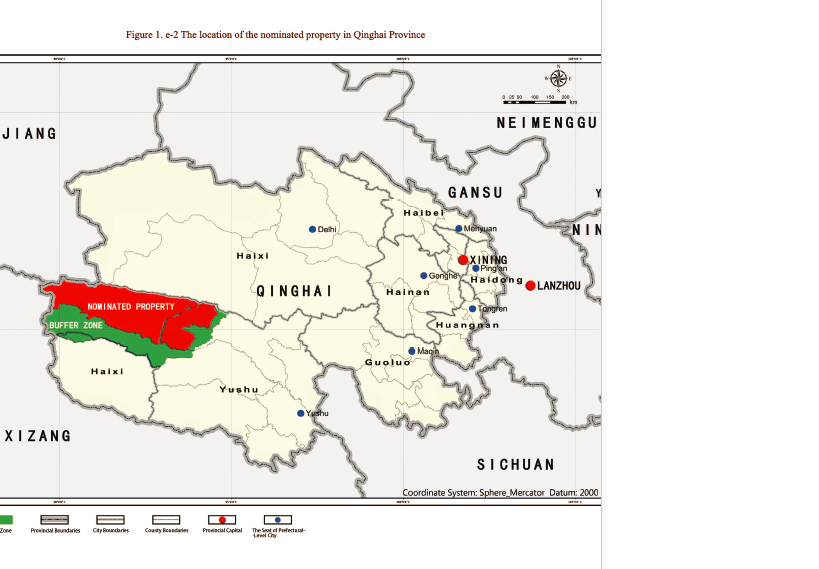
At the centre of this great ribbon is Hoh Xil, with the Changtang nature reserve to its west, the Sanjiangyuan (Three River Source) nature reserve to its immediate south and east. If Hoh Xil becomes a World Heritage property, when the UNESCO World Heritage Committee at its July 2017 meeting in Poland, China will be well positioned to then nominate the contiguous nature reserves on either side. In fact, the proposal now before UNESCO already includes a large portion of the Sanjiangyuan as well as the Hoh Xil nature reserves. What China is asking UNESCO to approve is not only the 45,000 km2 that comprises the Hoh Xil, but also 32,000 km2 of Sanjiangyuan, which extends Hoh Xil south as far as the banks of the upper Yangtze. The 77,000 km2 China is nominating is close to twice the size of Switzerland.
An alternative, overlapping proposal was announced officially in March 2016, covering an even greater area, which did acknowledge the presence of at least 20,000 Tibetans: “A meeting of the Central Leading Group for Reform at the end of 2015 decided to upgrade the Sanjiangyuan Nature Reserve, established in 2000 in northwest China’s Qinghai Province, into a national park managed by the central government. The Sanjiangyuan National Park will cover 123,100 square kilometres. The Yangtze River area of the park alone will span 90,300 square kilometres including 15 villages and more than 20,000 people. Local people will remain in the park, following their traditional way of life, said Lyu Yuan, a spokesman for Yushu city’s environment protection office. The headwaters of the Yangtze River will account for about 70 percent of the national park, including the Tuotuo, the Tongtian rivers and the Hoh Xil nature reserve, through which water from the glaciers of Tanggula Mountains flows into the Yangtze River.”[10]
The three interlocked nature reserves are separate only in their administrative histories, having been made official protected areas decades apart, first Changtang (Qiangtang) in 1993, as of 2001 no longer a provincial responsibility but a national one. National prestige and national face were now at stake. Hoh Xil was first proclaimed a nature reserve in 1995 and Sanjiangyuan in 2000. Hoh Xil is a Mongolian name. Literal meaning is blue ridge, in Mongolian Cyrillic Хөх шил and in traditional Mongolian script used in Inner Mongolia ᠬᠥᠬᠡ ᠰᠢᠯ. In standard simplified Chinese 阿卿贡嘉, literally meaning Lord of ten thousand mountains. However, in China it is usually called Kekexili, a transliteration of the Mongol name, which has more recently been made more accessible for Westerners by reverting to Hoh Xil, which is closer to the original.
These three nature reserves on the Tibetan Plateau are the biggest, but far from the only ones. A recent scientific report states: “To protect the environment, resources and biodiversity, 155 nature reserves have been created here since 1963, with a total area of approximately 8.22 × 10⁵ km2, accounting for 32.35% of the total area of the Tibetan Plateau.”[11]
A WILDERNESS FIT FOR MASS TOURISM
It is this political history that has resulted in three nature reserves, initially created to display modernity, then to legitimate grazing bans, nomad removals and the exclusive use of rangelands as grassland wilderness, the open range analogue of the virgin rainforest.
China’s argument for nominating Hoh Xil is full of the language of romanticism: “Magnificent scenes of mammal migration… fully preserved plateau surfaces….. Untraversed conditions make Hoh Xil the best preserved region in terms of pristine ecology….”
China’s official media routinely call these nature reserves a paradise, and a “no-man’s land.”[12] In the sharply dualistic thinking inherent in Chinese attitudes, it is the “untraversed”, uninhabited no-man’s land that makes these landscapes a paradise. Another tourism manager says: “There is also called “life forbidding zone”. Because of the bad climate and traffic conditions, human could not live here, so, there be the heaven of wild animals. Without human active, wild animals are host there. Now they are well adapted to the area. Now Qiangtang nature reserve is paradise of the wild animals.”[13]
Now this paradise is set for a new kind of human presence: tourism. Travel companies in China advertise tours.[14] For wealthy, speedy urban Chinese, there is a ready market for heavenly paradise.
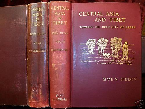 The language of the tour companies, and the World Heritage promoters, could be taken directly from the 1901 expedition through Hoh Xil led by the imperious Sven Hedin, who reports that he and his many helpers “plunged into a region which was an absolute terra incognita…. Desolate as the moon…. It was a delicious feeling, to know that we were the first human beings to tread these mountains, where there existed no path, where there never had been a path… It was a no-man’s land: rivers, lakes and mountains were all nameless; their shores, banks and snow-fields had never been seen by any traveller’s eyes but mine; they were mine own kingdom of a day.”[15] Hedin chose to travel at the height of the rainy season, in August, resulting in many pack animals –horses and camels- getting bogged, and dying.
Bisecting these contiguous nature reserves is the multi-modal transit corridor connecting inland China with Tibet Autonomous Region. This old trade caravan route now carries the only railway to central Tibet, the major highway, oil and petroleum pipeline, and fibre-optic cabling, plus an ultra-high voltage power line bringing electricity from Qinghai to Lhasa. This is known to China’s central planners as the QTEC, or Qinghai Tibet Engineering Corridor.[16] For 250 kms, it cuts across the putative Hoh Xil World Heritage property. The rail line has four stations already built, according the map accompanying China’s nomination papers submitted to UNESCO. (fig. 1-e3) At present, trains seldom stop, because the altitude is high, the air thin (especially when stepping from a train pressurised like an aircraft), and there seems to be little to see or do. All this will change once UNESCO declares Hoh Xil to be World Heritage, awarded global brand equity by the United Nations.
For China, Tibet has become a mass tourism destination, with official media claiming that as many as 15 million tourists now visit TAR annually, five times the resident population. Yet mass Chinese tourism to Tibet remains heavily concentrated in Lhasa, with few other destinations known to the market. China’s planners have invested heavily in recent years in airports and transport hubs near Mt Kailash in the far west, at Nyingtri (Ningqi in Chinese) in the southeast, Chamdo further east, and in Nagchu, north of Lhasa. The plan is to make TAR a circuit, encouraging tourists to stay longer, and spend more. Having a World Heritage no-man’s land paradise halfway en route from Lanzhou and Xining, on the way to Lhasa, fits well with these diversification plans.
China frequently names tourism as the future of Hoh Xil, along with assurances that it will be monitored and regulated. It is clear from China’s nomination proposal that tourism, presently almost non-existent, is to be big. Along the 250 kms of railway running right across the Hoh Xil World Heritage property, and four stations, the tour companies will be able to offer express trains direct to Lhasa for the time-constrained; and a safari to the breeding grounds of the iconic chiru antelope –official mascot of the 2008 Olympics- for the more adventurous tourist; all without the inconvenience of encountering a local human population on their own land.
TIBETAN PERSPECTIVES
Cutting an engineering corridor right through the middle of a “no-man’s land paradise” indicates the contradictions. To be a paradise, and worthy of World Heritage listing, this “wilderness” must be pristine, yet also accessible if World Heritage listing is to be meaningfully monetised. It also highlights the quite different view Tibetans have taken of landscapes that do have human uses, seasonally and intermittently, that are entirely compatible with migratory herds of wild animals. In Tibetan eyes “wilderness” and “productive rangeland” are not mutually exclusive, as George Schaller reminds us when he quotes a Tibetan folk song:
“On the highland humans and nature coexist harmoniously!
The land where spiritual and human law reign supreme.
In the land where celestial powers are revered,
Where animals are partners in life’s struggle,
Where birds fly without fear,
Where fish swim in freedom,
Where wildlife is protected,
Where men and women cherish inner peace and outer freedom.”[17]
These attitudes have enabled sustainable human use of these arid seasonal pastures for thousands of years. China’s census unmistakably records an ongoing human presence, yet China insists: “Most areas of the nominated property are uninhabited by humans.”
In common with drylands worldwide, the pastoralists of Tibet have not only made their livelihoods despite an unpredictable climate and much uncertainty, they make their living off uncertainty, off high mobility and high adaptability.[19] UNESCO has had a drylands program for many years, headed by Han Qunli from China, who argues that: “a general lack of investment in drylands are now putting extraordinary strains on the livelihoods of dryland inhabitants and the integrity of their ecosystems. Ensuring dryland inhabitants have viable livelihoods will be key to their survival.”[20]
Far from being uninhabited, the Hoh Xil and Sanjiangyuan drylands are Tibetan production landscapes populated by pastoralists who continue to care deeply about wildlife and the environment, and continue to risk speaking up. The current campaign led by Awang Jikme in Chumarleb, in the area now proposed as World Heritage, exemplifies the ongoing concern for effective protection,[21] based on the concept of Sacred Natural Sites (SNS), which places biodiversity protection in local community hands, and because it is the cheapest and most effective way of ensuring endangered species are in reality protected.

The concept of Sacred Natural Sites was brought to this would-be World Heritage area by Conservation International, one of the world’s biggest environmental NGOs. Although CI is no longer in the Hoh Xil, its concepts took root among the Tibetan communities, who readily understood that SNS is community based, by and of local communities whose values have always respected living sentient beings, and actively cared for them, as a previous Tibetan generation did in Hoh Xil in the 1990s, even dying to protect the chiru antelopes.
SNS is a concept with wide support, as a major alternative to top-down interventions by bureaus of state power. UNESCO World Heritage should seriously consider whether, in Hoh Xil, biodiversity protective outcomes are better achieved by making Hoh Xil a Sacred Natural Site, preferably with external support.
Other Chinese environmental NGOs have worked, in Hoh Xil and nearby counties, with Tibetan communities, to strengthen biodiversity protection. This cooperation between global, Chinese and Tibetan NGOs, to improve conservation effectiveness, has been well-documented in freely available accounts of how they have worked together.[22]

CLIMATE CHANGE, ENGINEERING CORRIDORS AND PRISTINE GLACIAL SOURCES
The QTEC corridor for projecting modernity deep into Tibet, extending the reach of the state, is something China is proud of. There have been many technical articles extolling QTEC achievements. Yet the siting of QTEC came decades before any consideration was given to environmental protection. It was only well after the first highway construction in the 1950s, the oil pipeline from the Tsaidam Basin to Lhasa in the 1980s, and the laying of optical fibre cables in the 1990s that China noticed two competing land uses, two contradictory narratives about this corridor and its immediate environs, which include the farthest source of the Yangtze, China’s greatest river. By the time the ultimate source of the Yangtze was identified by scientific expeditions, it was already running near the highway, later joined by much other infrastructure for extending state power and thus state sovereignty.
Tibetan chiru antelope were slaughtered indiscriminately by hungry Chinese soldiers for decades, and encouraged cadres to regard them as game available to anyone with a rifle, an attitude George Schaller witnessed among cadres in Changtang in more recent times.
After the sharp decline in chiru numbers, new policies requiring Tibetan pastoralists to erect fences, killed many more migrating chiru, either by snagging on barbed wire, or because their seasonal migrations were interrupted.
The QTEC corridor, with its five infrastructure technologies of ultra-high voltage cables, oil pipeline, optical fibre cable, railway and highway, also disrupts the free movement of the chiru and other wild species, a subject studied closely by Chinese scientists. In 2011 a team of Chinese and Scottish scientists reported on the results of their research among the antelopes: “As distance from the road increased, time spent foraging and foraging duration increased while foraging frequency, time spent being vigilant and vigilance frequency decreased, indicating that there is a risk perception associated with roads. Tibetan antelopes presented more risk-avoidance behaviours during high-traffic periods compared with low traffic periods. Tibetan antelopes exhibited risk-avoidance behaviour towards roads that varied with proximity and traffic levels, which is consistent with the risk-disturbance hypothesis. The consequences of risk-avoidance behaviour should be reflected in wildlife management by considering human disturbance and road design.”[23]
Despite these cumulative assaults on the chiru population, little mentioned in China’s UNESCO proposal, the people singled out for exclusion from the protected area are the Tibetan pastoralists.
*********************
If you wish to join the campaign to make Hoh Xil a Sacred Natural Site, under Tibetan community control, please contact:
Stephan Dömpke
World Heritage Watch e.V.
Palais am Festungsgraben
10117 Berlin, Germany
Tel. +49 (30) 2045-3975 landline
contact@world-heritage-watch.org
[1] Wang Lei, Tracking Down Tibetan Antelopes, Foreign Languages Press, Beijing, 2004, 95. Foreign Languages Press is a Chinese government press.
[2] Tibet Outside TAR, 1997, 2386
[3] The Discovery History of Mineral Deposits of China: Tibet Autonomous Region, Geological Publishing House, 1996, 38-40
[4] Discovery History, 38, 40
[5] Discovery History, 61-2
[6] Fu XG, Wang J, Zeng YH, Tan FW, Feng XL (2010a) REE Geochemistry of marine oil shale from the Changshe Mountain area, northern Tibet, China. Int J Coal Geol 81(3):191–199
Fu XG, Wang J, Zeng YH, Tan FW, Feng XL (2011) Concentration and mode of occurrence of trace elements in marine oil shale from the Bilong Co area, northern Tibet, China. Int J Coal Geol 85(1):112–122
Fu X, Wang J, Zeng Y, Tan F, Feng X (2012) Trace elements in marine oil shale from the Changshe Mountain area, northern Tibet, China. Energy Sources Part A 34(24):2296–2306
[7] Xiugen Fu • Jian Wang • Yuhong Zeng •Fuwen Tan • Xinglei Feng, Trace elements and their behaviour during the combustion of marine oil shale from Changliang Mountain, northern Tibet, China; Environ Earth Sci (2013) 70:1125–1134
[8] Verbal communication with Gabriel Lafitte, Delhi, November 2011
[9] Kekexili PA http://protectedplanet.net/315691 , Qiangtang PA http://protectedplanet.net/95786 Sanjiangyuan PA http://protectedplanet.net/sanjiangyuan-nature-reserve Aerjinshan PA Xinjiang http://protectedplanet.net/96114
[10] China plans national park to protect headwaters, Xinhua 2016-03-11
http://news.xinhuanet.com/english/2016-03/11/c_135180000.htm
[11] ZHANG Yili, HU Zhongjun et al., Assessment of effectiveness of nature reserves on the Tibetan Plateau based on net primary production and the large sample comparison method, Journal of Geographic Science. 2016, 26(1): 27-44
[12] http://news.xinhuanet.com/english/2009-08/10/content_11855685.htm
[13] http://www.tibettravel.org/tibet-travel-guide/932.html
[14] http://www.tibettravel.org/tibet-travel-guide/932.html
http://www.chinatouradvisors.com/blog/Qiangtang-Nature-Reserve-in-Qinghai-2959.html?id=2959
[15] Sven Hedin, Central Asia and Tibet: Towards the holy city of Lhasa, vol 1, 1903, 513
[16] Hui-jun Jin , Qi-hao Yu, Shao-ling Wang, Lan-zhi Lü, Changes in permafrost environments along the Qinghai–Tibet engineering corridor induced by anthropogenic activities and climate warming; Cold Regions Science and Technology 53 (2008) 317–333
[17] Lobsang Lhalungpa, Tibet: The sacred realm, 1983; quoted in Schaller, Tibet’s Hidden Wilderness, 139
[19] Saverio Kratli, Valuing variability: New perspectives on climate resilient drylands development, International Institute for Environment & Development, 2015
http://www.iied.org/advocating-for-policies-laws-support-adaptive-management
[20] Foreword by Han Qunli in: Richard Thomas et al., Drylands: Sustaining Livelihoods and Conserving Ecosystem Services: A policy brief based on the Sustainable Management of Marginal Drylands (SUMAMAD) project, UNESCO/UN University 2014
[21] ngangwangjikmed@gmail.com
phone +86 – 17708002238
wechat awang337126134
[22] Xiaoli Shen and Jiaxin Tan; Ecological Conservation, Cultural Preservation, and a Bridge between: the Journey of Shanshui Conservation Center in the Sanjiangyuan Region, Qinghai-Tibetan Plateau, China; Ecology and Society, 2012, 17(4): 38 http://www.ecologyandsociety.org/vol17/iss4/art38/
[23] Xinming Lian, Tongzuo Zhang, Yifan Cao, Jianping Su and Simon Thirgood, Road proximity and traffic flow perceived as potential predation risks: evidence from the Tibetan antelope in the Kekexili National Nature Reserve, China; Wildlife Research, 2011, 38, 141–146
4 replies on “SAVING CHIRU ANTELOPES OF “NO-MAN’S LAND””
[…] Serious concerns about China’s nomination for UNESCO status had already been raised in a substantive report by IUCN, which sent a scientific evaluation team to Hoh Xil last year. IUCN raised major concerns about the exclusion of herders and the dangers to wildlife presented by unqualified endorsement by UNESCO, including to the iconic species, the Tibetan antelope, adopted by China as mascot for the Olympic Games in 2008. Tibetans such as Sonam Dargye lost their lives protecting the Tibetan antelope, or tsö, from poachers in Hoh Xil. (See Gabriel Lafitte’s blog.) […]
[…] Ernstige bezorgdheid over China’s nominatie voor de UNESCO-status was eerder reeds aan de orde gesteld in een inhoudelijk verslag van IUCN, die vorig jaar een wetenschappelijke evaluatie team naar Hoh Xil had gestuurd. IUCN stipte ernstige punten van zorg aan over de uitsluiting van herders en de gevaren voor de wilde dieren bij ongekwalificeerde goedkeuring door UNESCO, waaronder voor de iconische soorten, als de Tibetaanse antilope, door China geadopteerd als mascotte voor de Olympische Spelen in 2008. Tibetanen, zoals Sonam Dargye verloren hun leven voor de bescherming van de Tibetaanse antilope (chiru in het Tibetaans) tegen stropers in Hoh Xil. (Zie Gabriel Lafitte’s blog) […]
[…] Ernstige bezorgdheid over China’s nominatie voor de UNESCO-status was eerder reeds aan de orde gesteld in een inhoudelijk verslag van IUCN, die vorig jaar een wetenschappelijke evaluatie team naar Hoh Xil had gestuurd. IUCN stipte ernstige punten van zorg aan over de uitsluiting van herders en de gevaren voor de wilde dieren bij ongekwalificeerde goedkeuring door UNESCO, waaronder voor de iconische soorten, als de Tibetaanse antilope, door China geadopteerd als mascotte voor de Olympische Spelen in 2008. Tibetanen, zoals Sonam Dargye verloren hun leven voor de bescherming van de Tibetaanse antilope (chiru in het Tibetaans) tegen stropers in Hoh Xil. (Zie Gabriel Lafitte’s blog) […]
[…] Serious concerns about China’s nomination for UNESCO status had already been raised in a substantive report by IUCN, which sent a scientific evaluation team to Hoh Xil last year. IUCN raised major concerns about the exclusion of herders and the dangers to wildlife presented by unqualified endorsement by UNESCO, including to the iconic species, the Tibetan antelope, adopted by China as mascot for the Olympic Games in 2008. Tibetans such as Sonam Dargye lost their lives protecting the Tibetan antelope, or tsö, from poachers in Hoh Xil. (See Gabriel Lafitte’s blog.) […]