Blog two of five on an industry totally new to Tibet: mass manufacture of millions of alien trout in hydro dams on the Ma Chu/Yellow River

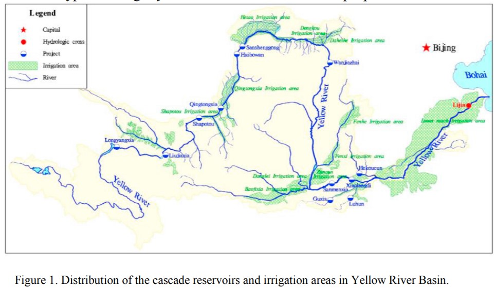
Of the many dams China has built athwart the Ma Chu in Amdo, by far the biggest in size is the highest, Longyangxia, although other dams below generate more electricity. Longyangxia, completed in 1987, is also the oldest of the Amdo dams, built at a time when most of the CCP Politburo Standing Committee were engineers. Initially fish cultivation in reservoirs was a distant dream, although the UN Food & Agriculture Organisation helped set up fish farming, in Longyangxia, as early as 1990.
| རྨ་ཆུ། | ||||
| ཨང་གྲངས། | ཆུ་མཛོད་མིང་། | རྫོང་། | ཁུལ། | གནས་བབས། |
| 1. | Ma er dang 玛尔挡 མར་སྟེང་། Marteng | རྨ་ཆེན། It’s in Ragya Town. | མགོ་ལོག། | 2018 བཟུང་བེད་སྤྱོད་བྱེད་བཞིན་པ། |
| 2. | Yang qu 羊曲 གཡང་འཁྱིལ། Yangkyil | བྲག་དཀར། | མཚོ་ལྷོ། | 2016 བཟུང་བེད་སྤྱོད་བྱེད་བཞིན་པ། |
| 3. | La xi wa 拉希瓦 ལ་ཟེ་བ LaSewa | ཁྲི་ཀ། | མཚོ་ལྷོ། | 2010 བཟུང་བེད་སྤྱོད་བྱེད་བཞིན་པ། |
| 4. | Li gorge | ངོས་མ་ཟིན། | 1999 བཟུང་བེད་སྤྱོད་བྱེད་བཞིན་པ། | |
| 5. | Da Gorge | ངོས་མ་ཟིན། | 1998 བཟུང་བེད་སྤྱོད་བྱེད་བཞིན་པ། | |
| 6. | Long yang xia 龙羊峡 ཚལ་རྔ་འགག Tsal nga gak | གསེར་ཆེན། | མཚོ་ལྷོ། | 1992 བཟུང་བེད་སྤྱོད་བྱེད་བཞིན་པ། |
MA CHU LONGYANG GORGE DAM THROUGH TIBETAN EYES
The case for constructing Longyangxia was focussed on hydropower, flood control, provisioning of irrigation water and protecting the downstream Yellow River from damage by floating ice. These remain the key purposes, and scientific research suggests Longyangxia has met those targets.[1] All of these outputs constitute economic growth and are classified as poverty alleviation for the local communities, another win-win for all. In reality Tibetans were removed from their lands to make way for Longyangxia’s man-made lake, and more have been displaced since the dam waters rose, by encroaching desertification, which was not officially attributed to climate change but to overgrazing by ignorant herders.[2]
Czech anthropologist Jarmila Ptackova did ethnographic fieldwork at Longyangxia between 2007 and 2013, 20 to 26 years since Longyangxia dam wall was completed, enough time to assess the dam’s impacts on local Amdowa Tibetan communities. She further reported in 2016 on plans to build more dams upriver from Longyangxia, but these have not yet been built. “In Qinghai province, between the late 1970s and 2012, 47,640 people were forced to leave their original homes to make way for river dams and hydroelectric power stations, such as the Longyangxia, Lijiaxia, Gongboxia, Nina, Laxiwa, Kangyang, Zhiganglaka and Suzhi. Additional hydroelectric power stations – Bingling, Jishixia, Dahejia, Huangfeng, Banduo, Yangdian, Maerdang, Shitouxia and Nazixia – are under construction and will require the relocation of a further 51,855 people by 2020.
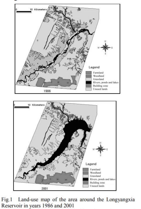
“The total surface area of the reservoir is 383 km2. The dam was built for the purposes of hydroelectric power generation, irrigation, ice control and the stair-step power stations along the Longyangxia-Qingtongxia section. The construction of Longyangxia began in 1976. With a height of 178 m, on completion. The actual damming of the river began the first relocations of affected residents to state-employed engineers’ assumptions on the river’s behaviour, the water level and has had a huge impact on the local and agriculturalist inhabitants.
“Due to the still increasing water level, new villages and fields continue to be flooded. Moreover, because of strong water-level fluctuations, land and fields that normally stand above the actual water level are also occasionally being shoaled and are not suitable for agriculture any more. Thus, 30 years after the completion of the dam and the launching of the hydroelectric power station in
1986, the water level of the Longyangxia is still rising and continues to impact the surrounding environment, necessitating the relocation of more and more people.
“During the first relocation phase between 1977 and 1991, in Gonghe County 34 villages in five townships—a total of 3852 households—were relocated to make way for the Longyangxia reservoir. On the southern side of the dam, in Guinan County, additional villages had to be moved. Due to the continuous increase of the water level, some households and village communities from the Longyang basin have been forced to relocate up to three times since the start of the dam construction.”
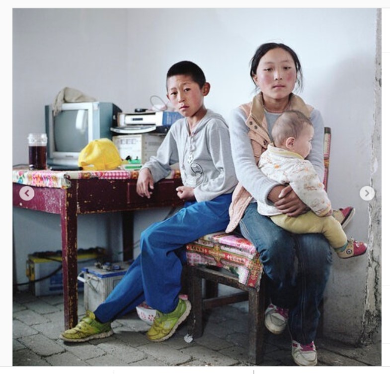
In her detailed ethnographic fieldwork, Ptackova found many displaced Tibetans had been samadrog, both crop farming and livestock raising on grassland, requiring access to pasture. On being resettled, the land allocated to them enabled cropping, but no space was provided for grazing, which wrecks the balance between the two modes of production, essential to subsistence. Worse, a livestock feedlot for intensive animal production was set up right next to their resettlement village, which the resettlers did not own, but had to live with the effluent pollution from it.
Hydraulic engineers describe hydro dams as stable and predictable, especially big ones like Longyangxia, which can release huge amounts of water without the water level changing much. But in the experience of Tibetan villagers, and the local government that allocated land to resettle, Longyangxia continued to rise, and villagers had to move again.
RELOCATION, DISLOCATION
Ptackova: “After only about two years, however, the village was again forced to move to a new location near Guomaying town. In the new settlement the houses were paid for and constructed by the government. Although use rights over some agricultural land were granted to the villagers, again no grazing space suitable for keeping livestock was made available and in the tight courtyards it is difficult to build even small animal sheds.”
Jarmila Ptackova takes us to the: “11 local Tibetan communities which were resettled when the Longyangxia canyon was flooded. The new village is situated close to the Guinan County seat, about 30 km away from the original site. Though these resettled Tibetans were also semi-pastoralists, the Lagan village has no pasturelands attached. On the available fields, the variety of possible crops is limited due to the colder climate. While in the former location the villagers planted tomatoes and melons, rapeseed is now the main crop. The relocated Tibetans families were granted some funds to build new houses by themselves.
“The villagers were informed about the damming project only when the construction works were already in progress and were assured that the water level would not reach their village and agricultural land. However, though Demang village was not among those originally to be flooded, it was affected at a later stage due to the unforeseen ongoing increase in the water table many years after the dam construction was completed. When the fields became flooded, the villagers demanded help from the local government, which decided to solve the problem through relocation.
“Though it did not destroy all the fields, the landscape changes inflicted by the construction of the dam caused severe logistical problems for the Tibetan community in the old Demang village. The village was situated 35 km from the Gonghe county town, which was also its nearest market place. Though the villagers had to cross the Yellow River on the way, the water level in this section was comparatively low and the river itself was relatively narrow. This changed with the construction of the Longyangxia dam and other dams and reservoirs further downstream. Since the Longyangxia canyon was flooded, the Demang villagers have to travel between 130 to 250 km around the reservoir in order to reach Gonghe.
“As in the majority of cases of relocation it also became more difficult for the villagers to reach monasteries and request monks to perform rituals, the lack of a public worship place has usually been among the main points of complaint in relocation sites. in the new Demang village also the prospective villagers were not consulted during the planning and design phase. As a result, the new concrete houses are considered uncomfortable by the majority of resettled villagers and those with sufficient financial means construct a second, wooden building in the style of a Qinghai farming house next to it. It is now these new wooden houses that serve as the main living quarters for the resettled families.
UNSETTLING THE RESETTLED
“The transformation into a water landscape destroys the ecosystems around the reservoir as animal and plant habitats vanish. Damming may also even enhance soil erosion and trigger earthquakes around the dams and reservoirs (International Rivers 2010), further negatively influencing the lives of the inhabitants of the affected areas. The secondary impact is felt in an indirect way over a long period and continues to have an influence on larger and more distant plots of land. When resettling the population away from the nascent reservoir, new sites have to be developed to host the new settlements, and it is often the case that hillsides or grassland are adopted for cultivation, such as in the case of Lagan village. The concentration of the population in new centralised settlements and the extensive use of local land, however, further exacerbate the degradation of the environment and thus lead to even more environmental resettlement projects. Moreover, the resettled population is exposed to rapid changes in livelihood and ‘involuntary relocation usually results in people being transferred from a social environment in which they were primary actors to one in which they are aliens’, a situation which can further lead to conflicts with the previous users of the land. The resettlement did not lead to the shift of household registration to the new location. Instead, the registration remained at the original village site, even though some of the communities were resettled to different counties. This leads to additional complications and hampers integration in the new administrative unit. Adapting to new locations is, of course, most difficult for elderly people, who find it hard to establish new social networks and join in the cash-generating labour.
“For the relocated people, however, major challenges begin with the implementation, when alternative livelihoods must be created. In new settlements, because no livestock is held, daily expenses usually rise. Thus, even when fields can provide food for the family, the majority of the younger generation have to seek out additional sources of income. In new settlements, potential for employment or business activity is limited, owing to the shortage of customers. Low education levels, limited Chinese language and management skills, low investment capacity and the inability to deal with the challenge of leaving the village additionally hinder the shift to a new profession and integration in urban economies.
“By placing the new settlements closer to towns and communication routes, the government obviously hopes to facilitate finding employment. However, the competition among unqualified workers is continuously on the rise owing to immigration of predominantly Han and Hui workers from other provinces. Therefore, even in settlements established more than 10 years ago, such as the one near Gumaying, a substantial portion of the population has been unable to find a sustainable substitute for their previous occupation and lives in a prolonged state of precariousness.”
COMMAND AND CONTROL
These nine dams on the Ma Chu in Amdo (Yellow River in Qinghai) fit into a wider context of damming. In 2019 the World Bank[3] reviewed China’s experience of hydro dams and displaced local communities, based on an in-depth investigation by the China Renewable Energy Engineering Institute (CREEI): “Since the 1970s, China’s planners have promoted hydropower projects as a strategically vital means to increase electricity generation for national development. The scale of hydropower development has increased significantly in more recent decades. More than 3,300 medium- or large-scale hydropower projects have been constructed — the Three Gorges Project being the largest and most famous — with China’s hydropower output now totalling about one-third of the global total. The construction of these sizable dams and the filling of the reservoirs behind them has caused population resettlement on a massive scale, with an estimated 24 million Chinese people relocated to accommodate hydropower schemes since the 1970s.
“The Chinese experience shows that relying solely on a command and control approach to land acquisition and resettlement will not promote successful resettlement. Affected people can restore their lives and livelihoods more quickly and efficiently if they are allowed — and encouraged — to be actively involved in their own rehabilitation. The CREEI Report highlights the importance of a people-centred approach in which people are provided timely and useful information about matters affecting them, are engaged in formulating plans, and have accessible and reliable means to raise complaints and concerns to relevant officials. The significance of this approach however is not solely that affected people are given a voice; it is that structured arrangements are in place to increase the probability that their voice will be heard and will get some form of response.”
Although Ptackova’s fieldwork shows local Tibetan communities get almost no say in how their displacement and resettlement are designed and implemented, according to CREEI and World Bank, China is learning to listen: “For the Gongboxia Hydropower Station Project, in response to affected persons’ preferences, special measures were planned to minimize cultural disruption for Tibetan, Hui and Salar minority members who were among those to be affected. In some instances, separate resettlement sites were prepared, or ethnically differentiated villages were provided within shared sites. Site planning included culturally appropriate housing design and layout, and religious facilities were provided at or near village centres.
“For the Yangqu Hydropower Station Project in Qinghai, planners recognized that normal valuation procedures for structures would not capture the less tangible sources of value Tibetans attached to religious facilities and activities that occur within them. The local resettlement officials instituted a consultative process with local religious leaders to determine appropriate replacement sites and appropriate means of support to enable religious leaders and adherents to agree to relocation arrangements.”
These are encouraging signs, yet no-one has ever asked Tibetan communities how they feel about farming alien trout by the millions, killing, gutting, chilling, packing and airfreighting them off to China’s wealthiest cities. It remains axiomatic, in the eyes of central leaders, that this is development and poverty alleviation, a benefit to the Tibetans.
DESERTIFICATION: SOMEONE MUST BE TO BLAME?
Ptackova’s fieldwork around Longyangxia dam villages concluded in 2013. While she was in the field the precarity of life among the Tibetans displaced was intensified by encroaching desertification. To the northwest, landscapes have been slowly desiccating over a long period, summer rains from distant Indian and Pacific monsoons have failed to arrive, desertification has crept towards these marginal villages. Tibetan villagers in these districts only ploughed the small areas that were fairly flat and well-watered. On relocation, they had to plough the grassland, only to see seasons where expected rains failed to arrive, turning exposed soils to dust, readily blown away by strong winds, with a loss of soil fertility. To make matters worse, they were blamed for desertification.
Work constructing the first big dam athwart the Ma Chu began in 1976. The last of the nine dams (so far) was completed in 2010. In those 34 years, much of Qinghai has desertified, especially along the Ma Chu near the Longyangxia dam. This has not been a problem for the river, which is plentifully watered from far upstream, not only from the source glaciers but from meandering over 1400 kms through lush alpine pastures and water meadows, slowly making its braided way across plateau land that is almost flat. Much further down the same river, the Huang He/Yellow River takes a massive turn north and then east through the deserts of Inner Mongolia, a lifeline for all production, from livestock to heavy industry.
But desertification in the northwest of the Tibetan Plateau greatly alarmed China’s policy makers, who were quick to attribute blame to “irrational” Tibetans, often the same folk who had been displaced by dams, no longer given access to sufficient grassland to graze livestock flexibly and sustainably, by moving on well before the frasses were exhausted. The displaced Tibetans often had to subsist solely by ploughing the soil, to rely on cropping, even though the experience of breaking the grassland soil in Inner Mongolia was disastrous, decades earlier.[4]
Both in Inner Mongolia and then in Qinghai the driver is wind, the result is aeolian desertification. There is nothing new about the fierce winds that blow hard from even deeper in inner Asia, capable of stripping bare earth of soil, leaving behind only pebbles and rocks. Much of the Chang Tang alpine desert of upper Tibet, in the west of the plateau, is a gibber plain of pebbles bared by those fierce winds. Even though Tibetan Zhang Zhung civilisation initially flourished in what is now a barren land, the wind drove then further and further east, leaving behind the remains of the irrigation channels and stone shelters built when these landscapes, thousands of years ago, supported human use.
China’s unfamiliarity with the deep history of Tibetan (and Inner Mongolian) landscapes, and with the long, slow history of creeping desiccation, led to alarm. Someone must be to blame. The obvious people to blame were/are the nomads of Tibet, even though, in this 21st century, past millennia of drying climate change has now reversed, and most Tibetan areas are now steadily getting wetter. That increase in rain and in lake levels, well measured by Chinese scientists, should suffice to drop blaming the nomads for desertification, yet the blame has outlived the science.
IRRATIONAL NOMADS MAKE DESERTS
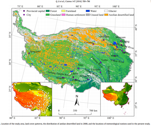
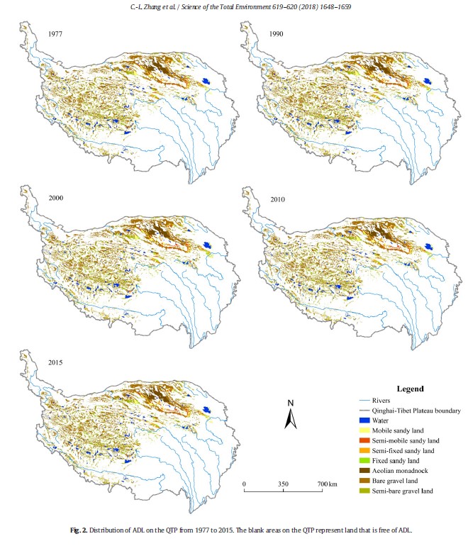
Recently, Chinese scientists have discovered they were wrong to assume the Tibetan Plateau, prior to China measuring it, was static and timeless, just like China’s assumptions about the Tibetans.[5] Far from being in equilibrium, the Tibetan Plateau was gradually drying, then climate change reversed the trend. The team of scientists who mapped the advance of windblown aeolian desertification to the shores of the Longyangxia dam; and then since 2000 the retreat of the desert, neatly attribute the reversal to climate change and China’s wise statist projects, while hanging the blame for pre-2000 desertification on “irrational” Tibetans.[6] This is in line with official policy, which no-one in China would dare to contradict.
“Aeolian desertification on the Qinghai Tibet Plateau QTP has changed from expansion to reversal since 1977. From1977 to 2000, aeolian desertification expanded throughout the plateau, and irrational human activity was the dominant factor responsible for the expansion of aeolian desertified land ADL. Since 2000, reversal of desertification was the dominant process, and the ADL area decreased gradually. Irrational human activities were the dominant factor responsible for the expansion of aeolian ADL prior to 2000, whereas the subsequent reversal was mainly caused by climate change combined with large ecological restoration projects. Overgrazing damaged the natural vegetation and the soil structure, thereby making the soil more vulnerable to the development of aeolian desertification. Additionally, other irrational human activities, such as grassland reclamation and deforestation, are common on the QTP. These activities also damaged the natural vegetation and the soil, making the soil more vulnerable to the development of aeolian desertification. Therefore, irrational human activities, such as overgrazing, are the main reason for the development of aeolian desertification during those periods.”[7]
The mention of deforestation and “grassland reclamation”, which means ploughing grassland to make it farmland, is a discreet and muted critique of official policies, followed by crediting China for more recently attempting to reforest what it deforested. Bottom line: nomads are irrational, and to blame.
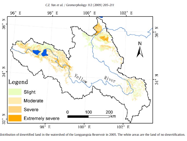
The advancing desert near the Longyangxia hydro dam deeply worried China’s central planners. Blame seemed to be due to Tibetans, both traditional pastoralists and relocated Longyang Gorge villagers relocated to the pasture lands, who “with little foresight” ploughed the grassland, despite average annual rainfall of only 300mm, often much less.
“The condition of grassland degradation was insignificant before the 1980s. The Longyangxia Reservoir had not yet been built, and grassland in the northern region of the Muge Bottomland was controlled by the military [state farm]. Moreover, the presence of inhabitants (approximately 30 000 in 1972) engaging in agriculture practices was scarce in the Muge Bottomland while the total sheep population of Guinan County was approximately 458 000, less than the theoretical carrying capacity number of 463 262 for pastureland in Guinan County. Human disturbance to grassland regions was therefore light prior to the 1980s. Grasslands in the region at that time were described as heavy and thick. Grassland degradation became severe during the 1980s and 1990s. The management of Muge Bottomland grasslands was handed over from the military to the local authorities increasing the agriculture population moving into the Muge Bottomland region. In 1986, the Longyangxia Reservoir had commenced operation and began to reserve water submerging some grassland underwater. The population of Guinan County reached 60 000 in 1995, double the 1972 population. The sheep population of Guinan County reached 932 458 in 1996, reaching well beyond the theoretical carrying capacity for pastureland in Guinan County. Grassland was cultivated intensively with little foresight being overgrazed by yaks and sheep leading to grassland degradation. Animal husbandry output began to decrease while the development speed of the regional economy began to falter due to this degradation. The grassland crisis reached severe levels of degradation by the 1990s.”[8]
This was the standard narrative, repeated endlessly in both scientific reports and policy statements. However, in more recent years, climate change has been acknowledged as a main driver of desertification. This recognition has occurred because climate change has now started to reverse the long historic trend towards drying, with rainfall and temperature increases.
DO DAMS TRIGGER LANDSLIDES?
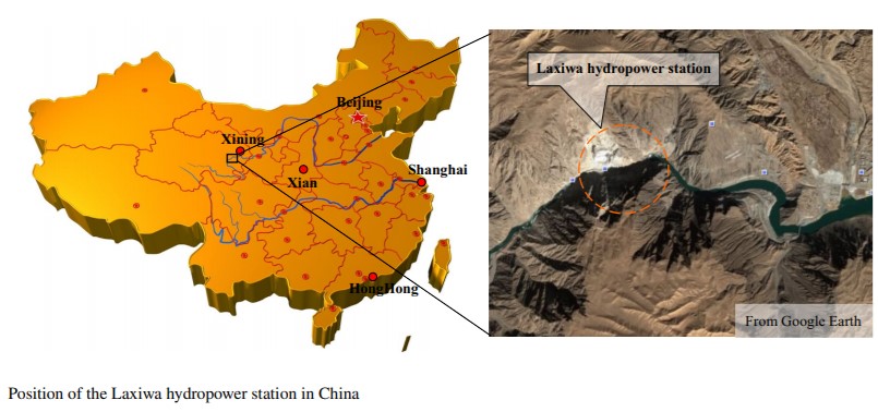
Longyangxia is one of nine hydro dams intercepting the Ma Chu below the new national park protected area of Sanjiangyuan, the Three River Source park. Other dams have also not worked out as planned. By impounded water area, Longyangxia is the biggest of the nine, but by electricity output the biggest is Laxiwa, further downriver.
Laxiwa is a dam wedged between granite canyon walls, a dramatic location that attracted the hydro engineers because it is a natural pinch point. The planned electricity generating capacity of Laxiwa’s turbines is 4200 megawatts (MW), which is more than three times what Longyangxia can generate. By comparison the three dams generating hydropower for Lhasa between them are capable of generating only 10 per cent of what Laxiwa was designed to produce.[9]
But this meant the turbines turning the down rush of captured water into electricity had to be in a huge excavated chamber blasted out of the granite, deep underground.
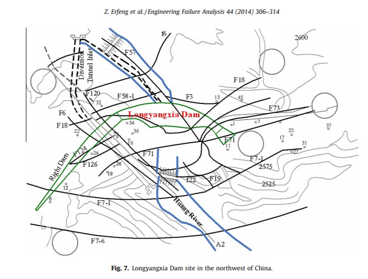
Granite is hard, having cooled slowly from molten rock pushed up from deep within, taking long enough to cool to form a crystalline structure. However, under renewed pressure, granite can fragment and even shatter, with dramatic consequences. In choosing granite walled Laxiwa as the location for a major dam, China’s hydro engineers took a great and expensive risk. What if the granite collapsed and crushed the underground turbine chamber? What if the rising waters of the Laxiwa dam lubricated fractures in the granite walls on either side of the dam?
Longyangxia was completed in 1987, Laxiwa in 2010, the newest of the Ma Chu dams (along with the smaller Jishixia dam further down the Ma Chu in Tsongkha/Haidong). There are reasons why the location appealed to engineers: “A high steep slope encourages the construction and operation of the high dams. First, the high slope itself is an important component of the overall structure of the dam providing the bedrock capable of bearing water load, resisting dam thrust forces and enabling the positioning of hydraulic structures. The low permeability of the rockmass may play an important role in controlling the water seepage in the reservoir and the slope with rock of good lithology is in harmony with the environment and so improves the overall stability of the dam. Second, a high slope is very helpful to the construction process enabling the provision of convenient traffic routes, the positioning of concrete mixing plant and the mooring of winch platforms and other large plant items within the slope.”[10]
However, the topography hydro engineers find so attractive has its dangers: “Sudden changes in water levels and earthquakes during the operation periods may all greatly affect the stability of the slope. Once the high steep slope becomes unstable, the resultant landslide of material into the water is likely to cause severe secondary disasters, such as the creation of dammed lakes, debris flow and even dam overtopping. The construction of the Three Gorges dam in China has triggered 430 landslides, and approximately 5400 other potentially dangerous sites have been identified and are being monitored. These landslides caused losses of billions of dollars and forced 100,000 people to leave their home village. Studies have shown that these landslides were caused by long-term water seepage, which saturated and weakened the face of the slope through the slow process of the slope immersion during the filling process of the reservoir.”
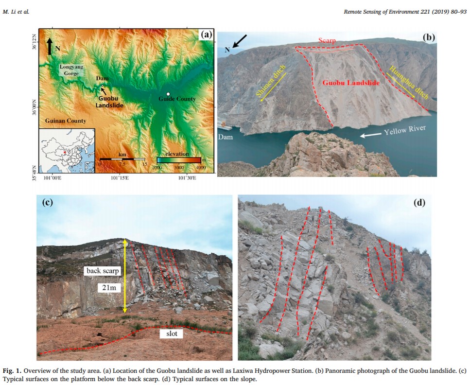
Filling of the Laxiwa dam began in the early spring of 2009. Within two months, before the summer rains that swell the Ma Chu, the granite canyon wall started to deform, so badly it was visible from satellites in orbit hundreds of kilometres above.[11]
”Because the deforming slope is about 700 m high and 1,000 m wide in average and is very close to the dam site, if collapse would occur, it could greatly damage or destroy the dam and other facilities. Besides, the possible wave would flood the downstream area, greatly threatening people living there and downstream hydraulic schemes.” [12]
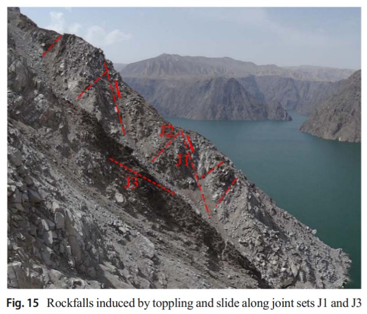
In 2016 the landslide accelerated, during an unexceptional summer monsoon, as rainwater infiltrated the rock face: “Although most of the daily precipitation was less than 10mm and almost no heavy rainfall larger than 36 mm/day occurred, the continuous rainfall may still have an impact on the landslide stability. Rainwater infiltrated into the cracking rock and increased the pore water pressure, which thereby decreased the shearing strength during potential slide/toppling events and thus intensified the deformation. Furthermore, stronger sunshine and larger day-night temperature differences in summer are likely to aggravate the weathering effects on the slope surface.”[13]
Chinese scientists say this is similar to the Vajont landslide in northern Italy in 1963, when 300 million cubic metres of rock crashed into the dam in just 45 seconds, sending such a huge amount of water over the top of the dam wall that 2500 people were killed. The cause of that landslide was the same as at Laxiwa, a reactivation of an old landslide, triggered by fluctuations in the reservoir level. If ever there was an accident waiting to happen………

[1] Jun Qiu et al., Evaluation of Environmental and Ecological Impacts of the Leading Large-Scale Reservoir on the Upper Reaches of the Yellow River, Sustainability, 2019, 11, 3818; htpps://doi.org/10.3390/su11143818
[2] Jarmila Ptackova, Making Space for Development: A Study on Resettlement from the Longyangxia Water Reservoir Area of Qinghai Province, Inner Asia , 2016, Vol. 18, No. 1, 152-166
[3] A Review Of Resettlement Management Experience In China Hydropower Projects: Identifying key lessons learned, World Bank, 2019,
[4] Dee Mack Williams, Beyond Great Walls: Environment, identity and development on the Chinese grasslands of Inner Mongolia, Stanford, 2002
[5] Guangyin Hu et al., Holocene aeolian activity in the Headwater Region of the Yellow River, Northeast Tibet Plateau, China: A first approach by using OSL-dating, Catena, 149 (2017) 150–157
[6] Chun-Lai Zhang et al., Monitoring of aeolian desertification on the Qinghai-Tibet Plateau from the 1970s to 2015 using Landsat images, Science of the Total Environment 619–620 (2018) 1648–1659
[7] Zhang, Monitoring of aeolian desertification, 2018
[8] Y. Feng et al., Assessment Of Grassland Degradation In Guinan County, Qinghai Province, China, In The Past 30 Years, Land Degradation and Development, 20: 55–68 (2009)
[9] The hydro dams generating electricity for Lhasa are Yamdrok Tso, operational since 1998, generating capacity 112.5 MW; Pondo, completed 2013, 160 MW generating capacity; and Drigung completed 2007, 100MW generating capacity. Lhasa’s rapid urbanisation has outpaced these expensive dams, resulting in the installation of an ultra-high voltage power grid from Amdo Gormo (Qinghai Golmud) to Lhasa to meet electricity demand.
[10] Peng Lin et al., Large Deformation Analysis of a High Steep Slope Relating to the Laxiwa Reservoir, China, Rock Mechanics and Rock Engineering (2016) 49:2253–2276
[11] Zhang DX, Wang GH, Yang TJ, Zhang MC, Chen SH (2013) Satellite remote sensing-based detection of the deformation of a reservoir bank slope in Laxiwa Hydropower Station, China. Landslides 10:231–238.
[12] Menghua Li et al., Monitoring active motion of the Guobu landslide near the Laxiwa Hydropower Station in China by time-series point-like targets offset tracking, Remote Sensing of Environment, Vol 221, February 2019, 80-93
[13] Menghua Li et al., Monitoring active motion