MORE HYDRO DAMMING, POWER GRIDS & CLOUD SEEDING GEOENGINEERING IN TIBET
Updating recent www.rukor.org reports:
RUKOR ANALYSIS: New hydro dams on Tibetan rivers, new propaganda for geoengineering, by cloud seeding the source area of China’s great rivers in Tibet.
China is already intervening on the ground in the huge Sanjiangyuan river source area, steadily depopulating the whole 300,000 sq km area, shifting the pastoralists to urban fringes, cancelling their land tenure and food security, leaving them reliant on official ration handouts, living under constant surveillance. Interventions on land, explicitly to enhance water provision for northern China, are now to be enhanced further by interventions in the sky.
Two stories below from Chinese media on cloud seeding Amdo Yushu and Golok prefectures of Tibet, to generate more rain for downriver China.
These stories, one in national media, one in a Qinghai weekly, both in Chinese, proclaim growing demand for geoengineering of Tibetan skies. Both stories are placed by vested interests which stand to benefit from attracting investment by central leaders in the technologies they command.

Both are highly misleading, as most special pleading by lobbyists usually is anywhere in the world, but Beijing has often fallen for these scientistic promises of miracles[1].
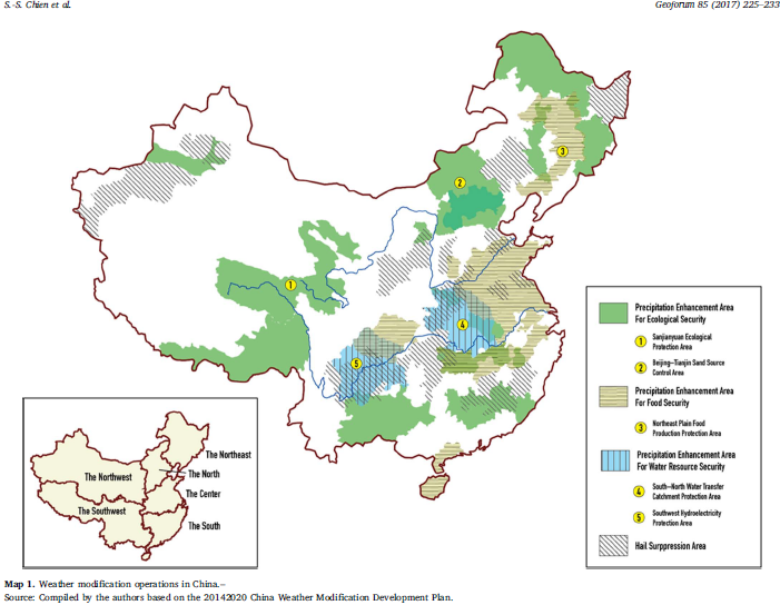
The first story championing remote imaging by satellite as the control mechanism for aerial cloud seeding over Yushu and Golok, a huge area of prime pasture that China now dubs the Sanjiangyuan or Three River Source region, claims to have discovered a “river in the sky” (tianhe in Chinese) that brings rain to Sanjiangyuan, an area bigger than Italy, which is to be enhanced by geoengineering. The river in the sky, the Milky Way of the night sky, is now a commodity to be milked of its cloud juice.
In reality Tibetans have always known where their rain, overwhelmingly summer rain, comes from, mainly the Indian and east Asian monsoons. Claims that the natural rainfall has already been increased by geoengineering are false. All over northern Tibet, both in Sanjiangyuan and in the arid land of lakes beyond, to the west, rainfall has been steadily increasing over the past two decades, as a result of global climate change, both in areas where the rivers rise and downriver China can harvest the water, and in the land of lakes that have no outlet, thus not available for downstream capture.
The other reason both the lakes and the rivers of northern Tibet are growing, also a consequence of global climate change, is the melting of glaciers. Chinese scientists have now measured this, acknowledging the dividend China reaps from increased runoff, while also calculating that China may enjoy this dividend for a further three decades, then the glaciers will be gone, and river flow will decline.
The longer Qinghai Scitech News story claims falsely that Sanjiangyuan lacks water, which would be news to the Tibetan pastoralists who have fattened their yak, sheep and goat herds on these lush, well-watered pastures, over thousands of years. If more water is needed “to improve production”, where are the official programs to improve pastoral livestock production, at a time when Sanjiangyuan is being emptied of human, yak, sheep and goat populations, in the name of climate adaptation?
The reality is that “the exceptionally large demand for water” is not within the pastoral areas but far below, in the big cities of northern China, in the chemical industries and coal fired power stations of Inner Mongolia, all dependent on the Yellow River. It is not Tibetan interests that are being looked after here.
Satellite to transfer water via ‘air corridor’ goes on display
http://www.ecns.cn/news/sci-tech/2018-11-06/detail-ifyzmsck5346142.shtml
6 Nov 2018 chinadaily.com.cn
A satellite model of China’s Tianhe Project, which aims to transfer water via an “air corridor”, is on display at the 12th China International Aviation and Aerospace Exhibition in Zhuhai, South China’s Guangdong Province.
According to the satellite’s commander-in-chief, Liu Weiliang, the Shanghai Academy of Spaceflight Technology is developing the satellite and its carrier rocket, and the first two satellites will be sent into space in 2020.
By 2022, a network of six such satellites will be formed, meaning the satellite will revisit the Sanjiangyuan area, north-western Qinghai province, every hour, or 24 times a day, and provide technological support to water vapour transportation in the air corridor.
Wang Guangqian, an academician with the Chinese Academy of Sciences, has led a team to discover that the atmospheric boundary layer and the troposphere form a stable passage through which water vapor moves.
The team named the passage “Tianhe” (literally, a river in the sky), and so the project it proposed has been named the Tianhe Project.
In the air over the Sanjiangyuan area, there are passages for water vapor from the western Indian Ocean, eastern Indian Ocean, Yunnan-Guizhou Plateau and Central Asia.
The Tianhe Project aims to use water resources in the air through manual intervention to benefit other regions of the country, making an overall plan for using water in the air and on the surface.
It will use the satellite network and the surface system. The satellites are Tianhe-1, and the system will be China’s first dedicated constellation of satellites to detect water resources in the air.
Zhu Wei, chief designer of the satellite, said that Tianhe-1 is a low-orbit satellite, and installed with a microwave hygrometer, precipitation measuring radar and cloud water detector to create three-dimension information of water resources over the Sanjiangyuan area.
A Science and technology sword guards the Tibetan plateau ecology
http://www.cnepaper.com/qhkjb/html/2018-11/07/content_5_1.htm Qinghai Scitech News 7 Nov 2018
Starting from Xining, we went up more than 500 kilometres along the Yellow River and arrived at Sanjiangyuan. This road is a contiguous lake, the river is clear, the grass is rich, and there are birds and cranes.
According to locals, 30 years ago, this was another scene: wetlands, swamps, and grassland degradation. The 30-year great change has benefited from the scientific research workers’ foothold on the plateau. The use of science and technology as a “sword” is also inseparable from the protection of grassroots meteorological observers for decades.
Escort for ecological construction
Although Sanjiangyuan is the source of rivers, it lacks water resources. For agriculture and animal husbandry to increase production and income, forest and grassland fire prevention, as well as wetlands, rivers and lakes, swamp protection, etc., the demand for water is exceptionally large. In Sanjiangyuan, the status of “water” cannot be overemphasized.
Since 2006, the meteorological department of our Qinghai province has carried out ecological protection type of artificial precipitation enhancement operations in the Sanjiangyuan area. “There is more rain, the grass is flourishing, the oxygen content of the air has also increased, the number of lakes has increased, and many wild animals have often appeared in groups.” Zhu Haicheng, observer of the Mado County Meteorological Bureau of Guoluo [Golok in Tibetan] Tibetan Autonomous Prefecture, said here. He has been stationed for more than ten years and witnessed the ecological changes of Sanjiangyuan.
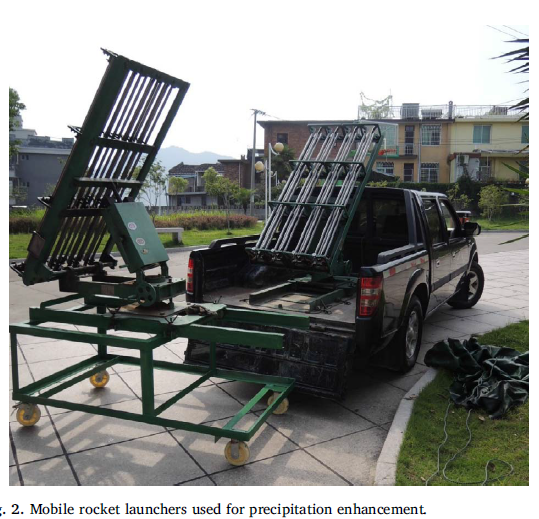
As early as 1997, our province carried out scientific experiments on artificial precipitation enhancement in the upper reaches of the Yellow River in the Sanjiangyuan area, and accumulated some experience about technical routes, operational models, and operational command. In recent years, artificial rain enhancement technology has been continuously improved and equipment has become more advanced.
Wang Lijun, deputy director of the Provincial Office of Weather-Affected Weather, said that for the unique plateau environment, they have broken through a number of core technologies, including pre-assessment techniques for artificial precipitation enhancement in the upper reaches of the Yellow River, physical inspection techniques for aircraft artificial precipitation enhancement, and Artificial rain enhancement effect numerical mode inspection technology.
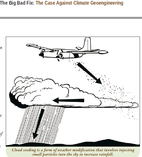
”Transfer water into the air” and scientifically develop airborne water resources can effectively solve the problem of insufficient water resources. Researchers have broken through the key technologies of Sanjiangyuan cloud microphysical properties and liquid supercooled water recognition to achieve “clouds for rain”.
Artificial precipitation technology is an ecological “escort”. In the past 12 years, the artificial precipitation in the Sanjiangyuan area has increased the precipitation by 57.719 billion cubic meters. The lake wetland area has expanded and the water conservation function has gradually recovered. Among them, the Yellow River source of Zhaling Lake [Kyareng in Tibetan] and Eling Lake [Ngoreng in Tibetan] increased by 5.69% and 10.68% respectively, and the river runoff and the reservoir capacity of the upper reaches of the Yellow River also increased significantly.
The source of the Three Rivers, the upstream of the weather and climate, is both a sensitive area for climate change and a fragile belt for the ecological environment. As an ecological barrier, it has a unique and extremely important position in China.
“Weather and climate as the most active and direct factors affecting ecosystems and atmospheric environment, there are complex and close interactions and feedback mechanisms between climate change and alpine ecological evolution, which has always been the focus and focus of the scientific community.” Xiao Jian, deputy director of the Provincial Institute of Meteorological Sciences, said that it is very important to improve the climate and ecological meteorological observation system as the basic data support.
Snow, glaciers, grasslands, water bodies… It’s critical to “manage well” the unique ecological elements of these plateaus. The Provincial Meteorological Science Research Institute has built a system of high-cold ecology and modern agriculture and animal husbandry meteorological observation and test bases, and has deployed many ecological monitoring meteorological stations throughout the province, realizing the automation from data receiving to processing, dynamic monitoring, and monitoring product generation.
Remote sensing data is important and human experience is equally important. The sample selection, height measurement, visual inspection of forage coverage, and grass weighing were used to estimate yield. Wang Xin, director of the Meteorological Station of the Guoluo Tibetan Autonomous Prefecture, said that during the pasture period from May to September each year, he and his colleagues will go to the plateau for pasture monitoring to analyse the pasture growth and possible disasters in the coming year.
On the plateau with an average elevation of 3,500 meters, it is mainly based on remote sensing observations, monitoring the elements such as pasture, rain and snow, rivers and lakes, wetlands, etc., as well as the “wind and grass movement” of disasters; supplemented by artificial ground monitoring, “checking for missing traps” Grassland that cannot be monitored by remote sensing. This combination not only makes the observation data more precise, but also further liberates the observer from the harsh environment.
The guardians of Sanjiangyuan
In addition to relying on advanced science and technology, the improvement of the ecological environment of Sanjiangyuan is inseparable from its guardians.
From Shangqiu in Henan to Yushu, the altitude rose from 60 meters to 4415.4 meters. “In the first half of the year, I almost never fell asleep.” Pan Wenzhong, 42 years old, still remembers the feeling when he first went to the Qingshuihe weather station in 1993.
Qingshuihe Town is the first township after crossing Bayan Kala Mountain. It is located in Yushu Tibetan Autonomous Prefecture, and the Qingshui River National Basic Weather Station is the third highest altitude weather station in our province. This year is the 23rd year of Pan Wenzhong as a meteorological observer. For 22 years, he spent the Qingshuihe meteorological station.
The oxygen content there is only 60% to 70% of sea level, only two seasons in winter and spring, and the lowest temperature is minus 40 °C. Despite the harsh environment, Pan Wenzhong and his colleagues had to record data on meteorological elements such as temperature, pressure, and humidity, and to maintain instruments and forecast disasters… There were not many contents, but the task was arduous and could not be taken lightly. “These information is of great significance to local traffic safety, animal husbandry development and ecological protection,” said Pan Wenzhong.
”Some people have come and gone, some people are not willing to come at all.” Pan Wenzhong self-deprecating that year was for “escape”, “because it gave me work.”
There are 54 grassroots meteorological stations in our province, but there are not many meteorological veterans like Pan Wenzhong. In the second half of last year, the Qingshuihe meteorological station also realized full automation and unattended operation. Basically, no meteorological observers were needed. Pan Wenzhong went down to the county meteorological bureau with an altitude of more than 3,000 meters.
”If you don’t adapt to it, you can do your job as long as you are on the station for one day.” Pan Wenzhong said that it is enough to contribute to the protection of Sanjiangyuan.
RUKOR ANALYSIS:
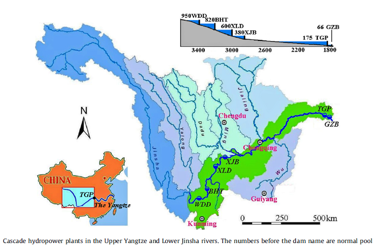
NEW HYDRO DAMS ON TIBETAN RIVERS, NEW POWER GRIDS CONNECTING TIBET HYDRO TO EAST CHINA FACTORIES
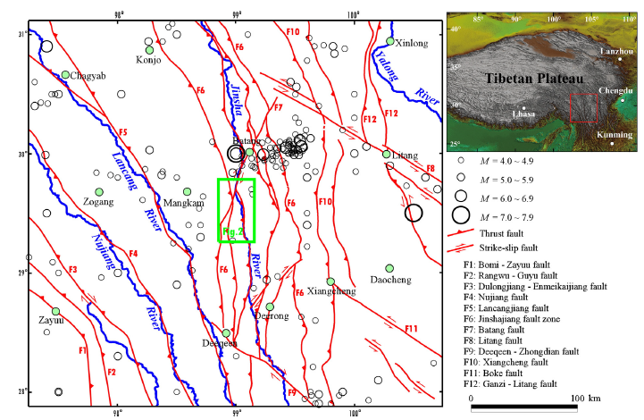
China authorises construction to begin on big hydro dam at Batang. All of the Tibetan Plateau is prone to earthquakes, but at Batang the danger is especially high. The valley of the Dri Chu/Jinsha River is a suture zone, where two huge tectonic block abut, and grind against each other. Just below Batang, earthquakes have been so severe that at times the Yangtze was blocked by massive landslides, only to be overtopped by natural dams, triggering further collapses and devastation downriver.[2]
The Lawa hydro dam, designed with an electricity generating capacity of 1680 megawatts, is to go ahead, according to a recent order issued by China’s State Council.
The dam is athwart the Dri Chu, or Jinsha in Chinese, known worldwide as the Yangtze, which forms the border between Tibet Autonomous Region to the west, and Sichuan province to the east. It is very close to the Tibetan town of Batang. Chinese scientists are increasingly worried that the sites selected by hydro engineers on the Dri Chu/Jinsha are extremely high risks for further massive landslides.[3]
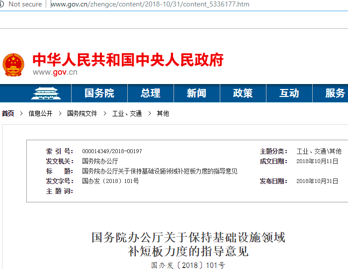
State Council notice 000014349/2018-00197, dated 31 October 2018, lists many infrastructure projects to be sped up, to counteract the general slowdown of China’s economy, and fears among central leaders that unless growth can be stimulated by, as usual, a burst of infrastructure construction, the population gets restless.
One such project is the Lawa 拉哇水电站 hydro dam, its’ precise location is 30°05′14″N 099°02′26″E.
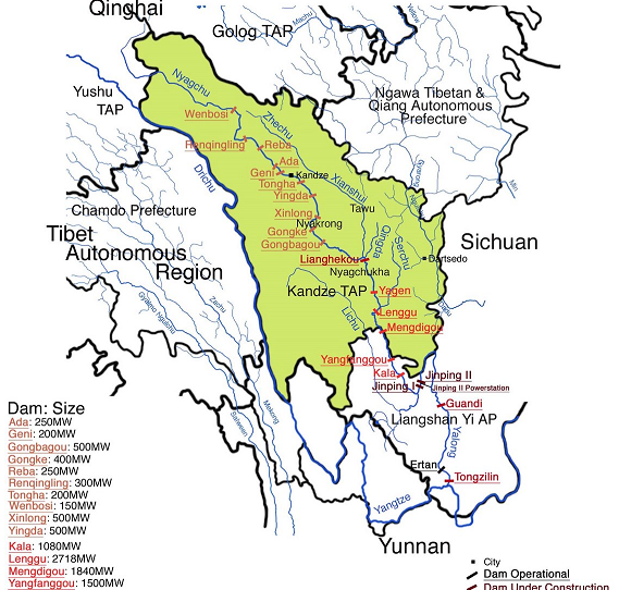
The other dam whose construction, and financing, has been ordered by this official State Council notice, is on the Nyag Chu, in Chinese Yalong Jiang, a major tributary of the Yangtze in Tibetan upper Sichuan. This is the Kara or Kala dam, which is just beyond (below) Kham Kandze prefecture. Its’ planned generating capacity is 1060 megawatts.
The same State Council directive further instructs an acceleration of construction of the ultra-high voltage (uhv) power grid from the Tibetan dams across China to coastal factory cities where the electricity will be consumed.
The idea that the whole of China could become one single power grid, even though the hydro potential is all in the far west, and the world’s factory largely on the east coast, is an idea that has seduced China’s leaders. It is an idea powerfully pushed by State Grid, the huge state-owned enterprise that stands to make the most profit from building and operating that grid.
But it may be a seductive idea whose time has come, and now gone. China is transitioning to energy efficiency, from heavy manufacturing to a services-based post-industrial economy, while the world’s factory, much of it now Chinese owned, is shifting its’ manufacturing plants to Southeast Asia, to Cambodia, Thailand, Vietnam, Bangladesh, Sri Lanka and more.
The question of whether China will need all the electricity that can be generated by damming Tibetan rivers is now actively debated in China, despite the seductive appeal of a nation made one, knitted together by those horizontal lines on the map, stretching from west to east across most of China, each line carrying as much as one million volts. Even the National Energy Bureau doubts whether China will actually need all the electricity planned to come from Tibet.

But the Chinese economy is slowing, as has been long foreseen, in the transition from mass manufacture of commodities to a high-income, high wage, consumer economy, the classic “middle income trap” economists talk about. If it slows too much, central leaders fear not enough jobs will be created, for new entrants to the labour market, and there will be social unrest. So the economy is being stimulated again, to accelerate growth, and hydro dams, long in the planning, ready for construction, are at the top of the queue.
[1] Shiuh-Shen Chien et al, Ideological and volume politics behind cloud water resource governance –Weather modification in China, Geoforum, 85 (2017) 225–233
[2] Chronology of relict lake deposits around the Suwalong paleolandslide in the upper Jinsha River, SE Tibetan Plateau: Implications to Holocene tectonic perturbations, Geomorphology · July 2014
[3] JIANG Shu et al, Long-term kinematics and mechanism of a deep-seated slow-moving debris slide near Wudongde hydropower station in Southwest China, Journal of Mountain Science, (2018) 15(2): 364-379